Vincentux
@[email protected] · Reply to Koreller's post
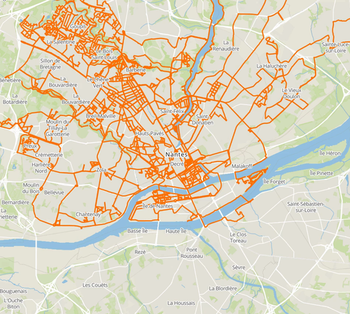
1er année pour moi sur Saint-Nazaire :
🛣️ 176 km de rues cumulées
📸 20 196 photos 360° prises
🎬 110 séquences
🕝 10 jours de capture étalés sur le mois d’août.
@[email protected] · Reply to Koreller's post
1er année pour moi sur Saint-Nazaire :
🛣️ 176 km de rues cumulées
📸 20 196 photos 360° prises
🎬 110 séquences
🕝 10 jours de capture étalés sur le mois d’août.
@[email protected] · Reply to Koreller's post
1er année pour moi sur Saint-Nazaire :
🛣️ 176 km de rues cumulées
📸 20 196 photos 360° prises
🎬 110 séquences
🕝 10 jours de capture étalés sur le mois d’août.
@[email protected] · Reply to Koreller's post
Cette année encore j'ai pu faire du Panoramax, niveau stats voilà ce que ça donne :
🛣️ 587 km de rues cumulées
📸 62000 photos prises en vélo
🎬 73 séquences
🕝 11 jours de capture
Merci encore pour le prêt du kit mobile [email protected] (de @cartocite) !
C'est rare mais ça arrive.... voilà une contribution que j'ai fait en France !
Bon, ce que je préfère, et ça ce voit aussi ici, c'est quand même lorsqu'il n'y a pas grand chose avant 😉
C'est rare mais ça arrive.... voilà une contribution que j'ai fait en France !
Bon, ce que je préfère, et ça ce voit aussi ici, c'est quand même lorsqu'il n'y a pas grand chose avant 😉
Do you actively use #OpenStreetMap? Yes? Great!
Do you support OpenStreetMap? By active editing? Cool.
Did you know you can become a paying member and support other activities with your contribution?
I just renewed my membership. You can do so, too.
Do you actively use #OpenStreetMap? Yes? Great!
Do you support OpenStreetMap? By active editing? Cool.
Did you know you can become a paying member and support other activities with your contribution?
I just renewed my membership. You can do so, too.
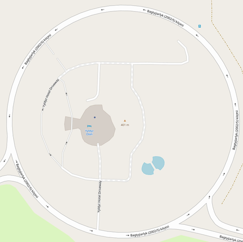
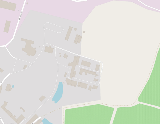
Petite cartographie de l'hôtel Yyldyz à Achgabat !
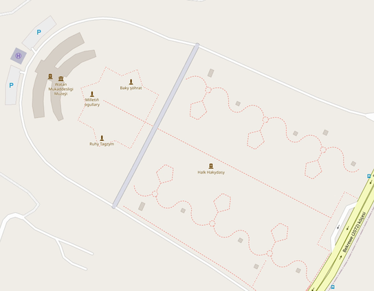
Carto du parc du Musée de la Terre sacrée (Watan Mukaddesligi Muzeýi, Sacred Homeland Museum) à Achgabat !
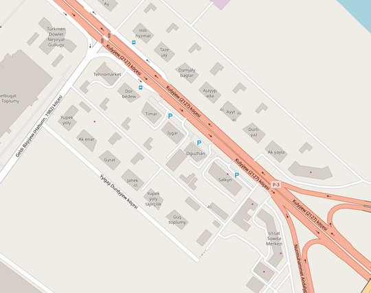
Petit tour cartographique le long de la route commerciale au nord d'Achgabat.
En vrai, j'ai fait ça sur 4 km mais je vous montre 1 km (Mastodon n'accepte pas mes plus gros gif 😅)
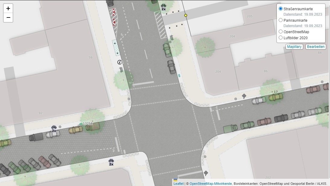
Ce style cartographique (basé sur les données #OpenStreetMap) qui se concentre sur le paysage urbain est magnifique 🤩
🖥 Le code source : https://github.com/SupaplexOSM/strassenraumkarte-neukoelln/tree/main/mapstyle
🗺 Un superbe exemple en ligne : https://strassenraumkarte.osm-berlin.org/?map=micromap#19/52.47391/13.43976
Thanks @Supaplex030 🙏
P'tite carto d'un bout d'truc.

Petit coloriage d'hier ☺️
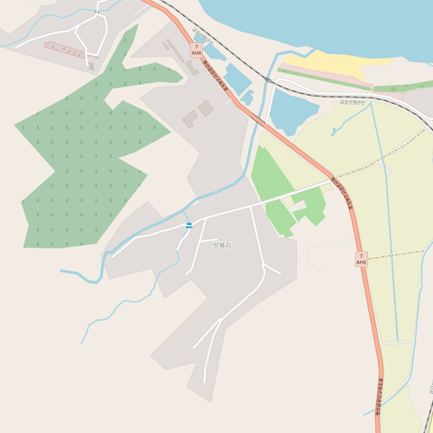
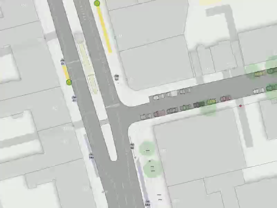
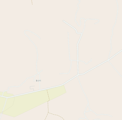
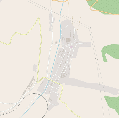
Cartographie dont je suis assez content. Le avant après est assez saisissant 😁. C'est dans la campagne nord-coréenne, dans le sud du pays dans l'arrondissement de Chongdan, dans et autour du village de Hongsan-ri.
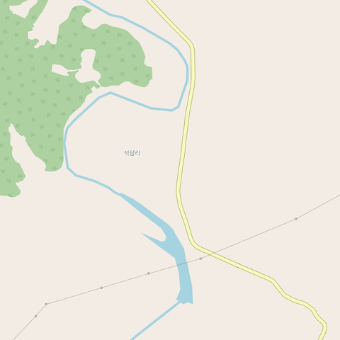
Ajout du village de Sokdam dans la campagne nord-coréenne.
Ma cartographie des 7 derniers jours.
Et la dernière image c'est la vue d'ensemble de la zone amélioré. Avez-vous trouvé où le deuxième GIF se trouve ? 😜
This is Mahatshula, or North Mahatshula. A large, newer suburb.
Location: https://www.openstreetmap.org/#map=16/-20.11250/28.63569
Cartographie de l'ilot Tudan-do à Pyongyang
Est-ce qu'on doit appeler ça une ile, un ilot ou c'est aucun des deux ? (une presqu'ile ?)
Pour ce gif je suis assez fière du travail réalisé, c'est la ville de Chongdan-up à l'ouest d'une large zone que j'ai pas mal cartographié !
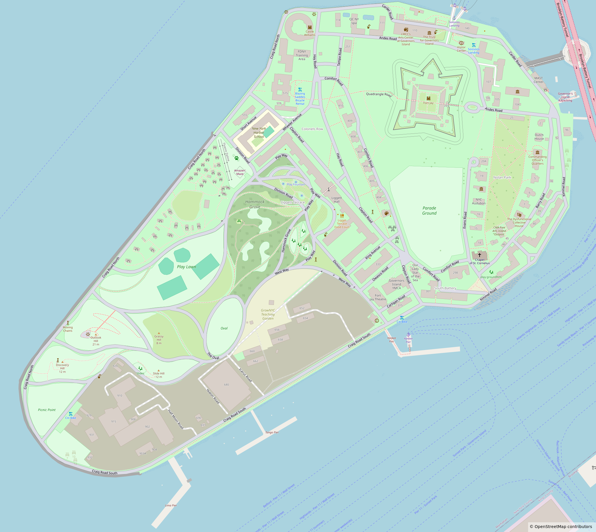
Finished micromapping Governors Island in New York a few days ago!
For anyone curious, I used a combination of Bing and NYS Orthos Online aerial imagery. The footpaths in the older areas came from a 1960’s US Department of Engineers tree survey map that had the island drawn in great detail. The rest of the information came from wikipedia articles and wikimedia + other license compatiable images. This resulted in 37,376 changes and a lot of hours of work
Petit carto à côté d'un lac et autour d'un monument.
Je cartographie la capital du Turkménistan, Ashgabat, depuis un bon moment mais je n'ai pas encore montré ici les avant/après, voilà donc le premier de la série !

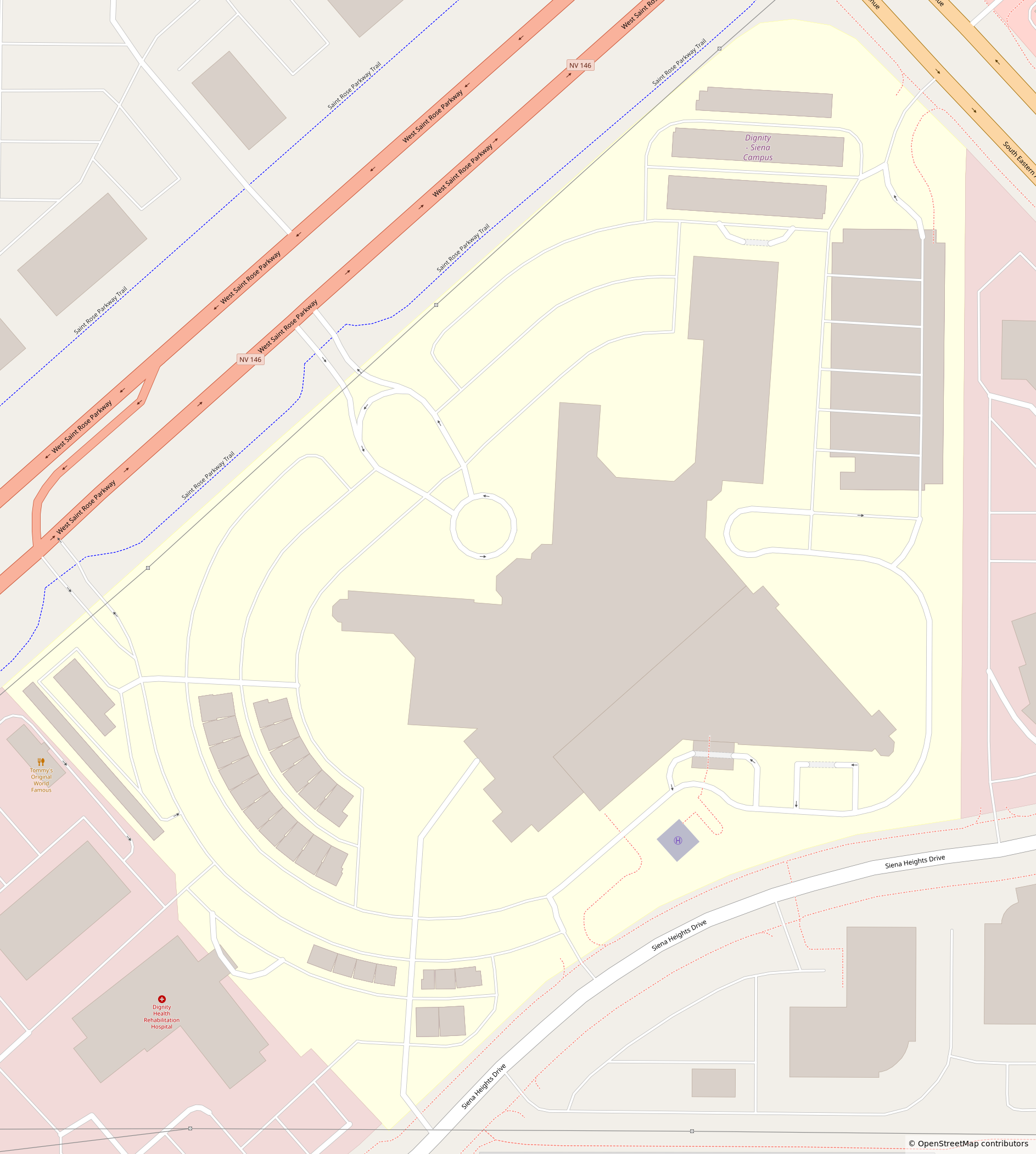
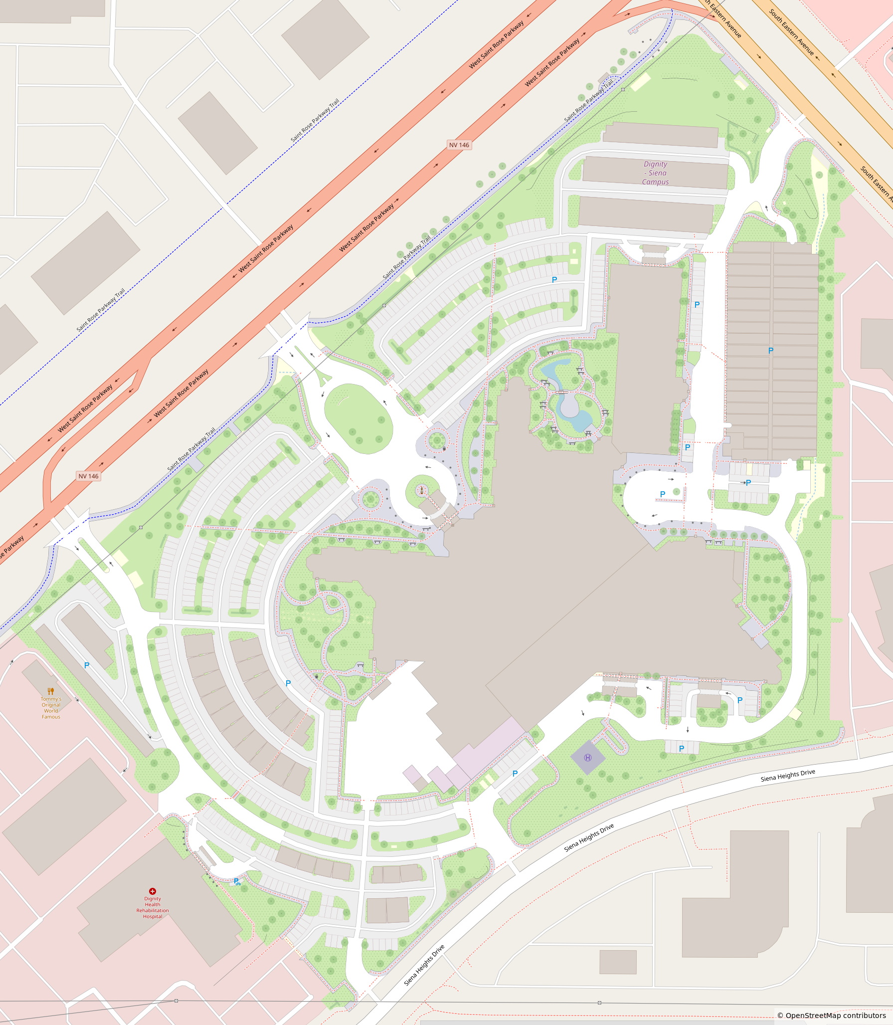
Micromapped Saint Rose Dominican Hospital's Siena Campus in Las Vegas this week to hopefully provide better accessibility and orientation for patients and visitors.
Petite cartographie de l'hôtel Yyldyz à Achgabat !
Carto du parc du Musée de la Terre sacrée (Watan Mukaddesligi Muzeýi, Sacred Homeland Museum) à Achgabat !
ICYMI yesterday: I've been writing about the diversity of tools for contributing to #OpenStreetMap and how this diversity plays a role in creating and maintaining a healthy commons.
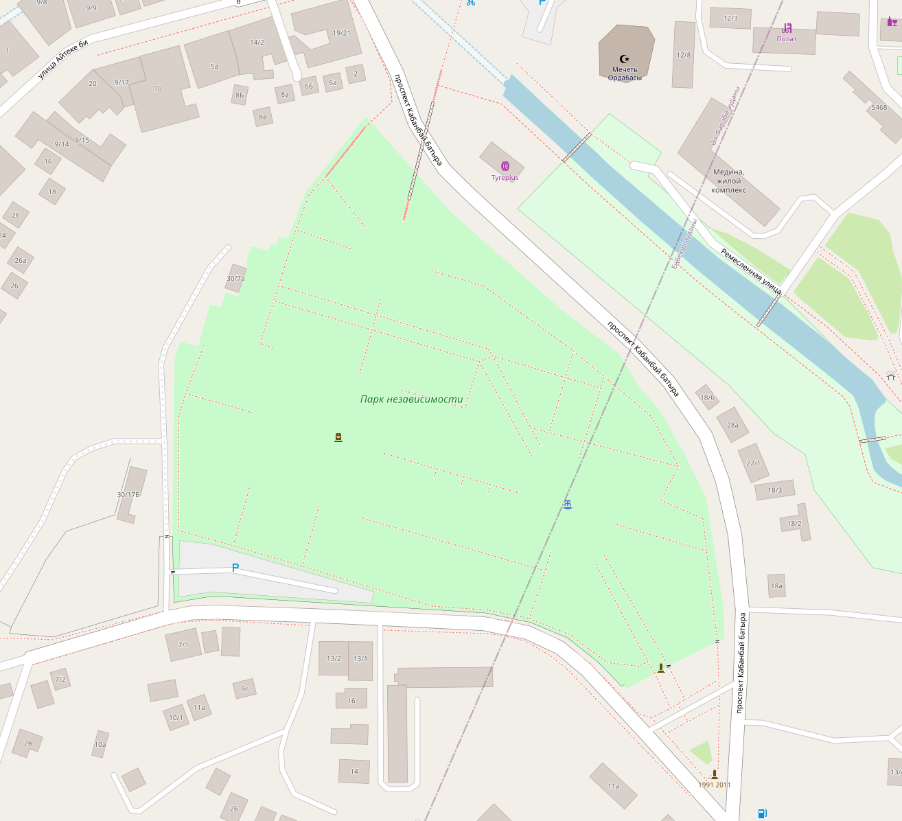
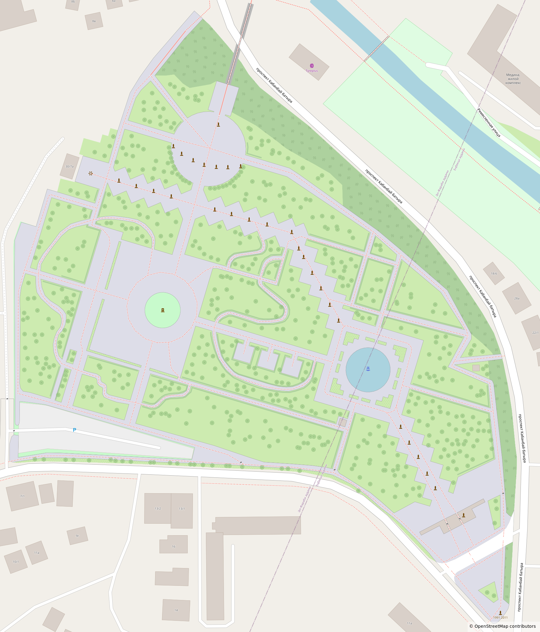
First time micromapping in Kazakhstan! Thanks @Koreller for the inspiration <3
Cartographie de l'ilot Tudan-do à Pyongyang
Est-ce qu'on doit appeler ça une ile, un ilot ou c'est aucun des deux ? (une presqu'ile ?)
Pour ce gif je suis assez fière du travail réalisé, c'est la ville de Chongdan-up à l'ouest d'une large zone que j'ai pas mal cartographié !
Carto du parc du Musée de la Terre sacrée (Watan Mukaddesligi Muzeýi, Sacred Homeland Museum) à Achgabat !
@[email protected] · Reply to Hugo van Kemenade's post
Just released: OSMViz 4.5.0! 🚀
An OpenStreetMap visualization toolkit for Python
🥧 Support for Python 3.14
🪪 Replace deprecated classifier with licence expression (PEP 639)
🔍 Remove GitHub attestation, PyPI attestation is enough
@[email protected] · Reply to Hugo van Kemenade's post
Just released: OSMViz 4.5.0! 🚀
An OpenStreetMap visualization toolkit for Python
🥧 Support for Python 3.14
🪪 Replace deprecated classifier with licence expression (PEP 639)
🔍 Remove GitHub attestation, PyPI attestation is enough
Stamen and #OpenStreetMap through the years, part 3
https://stamen.com/part-3-our-brilliant-friend-stamen-and-openstreetmap-through-the-years/
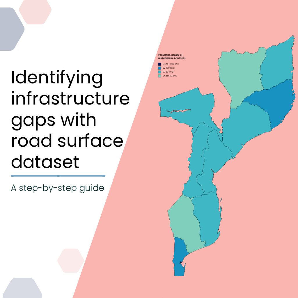
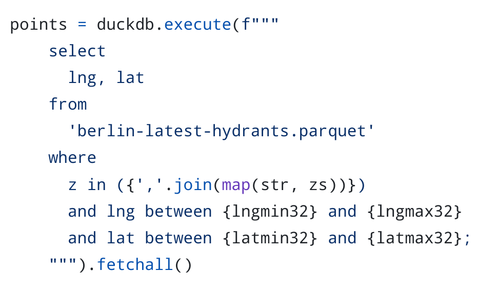
🌍𝐇𝐨𝐰 𝐜𝐚𝐧 𝐫𝐨𝐚𝐝 𝐬𝐮𝐫𝐟𝐚𝐜𝐞 𝐝𝐚𝐭𝐚 𝐡𝐞𝐥𝐩 𝐚𝐧𝐬𝐰𝐞𝐫 𝐛𝐢𝐠 𝐝𝐞𝐯𝐞𝐥𝐨𝐩𝐦𝐞𝐧𝐭 & 𝐡𝐮𝐦𝐚𝐧𝐢𝐭𝐚𝐫𝐢𝐚𝐧 𝐪𝐮𝐞𝐬𝐭𝐢𝐨𝐧𝐬?
📊 The tutorial shows how to combine our global road surface dataset with population data for Mozambique:
overlay road surface + population data
spot infrastructure gaps where many depend on poor/undocumented roads
explore data with open tools (DuckDB, Mercantile, Shapely)
👉 https://heigit.org/identifying-infrastructure-gaps-with-road-surface-dataset/
#GeoAI #OpenData #OpenStreetMap #Mapillary
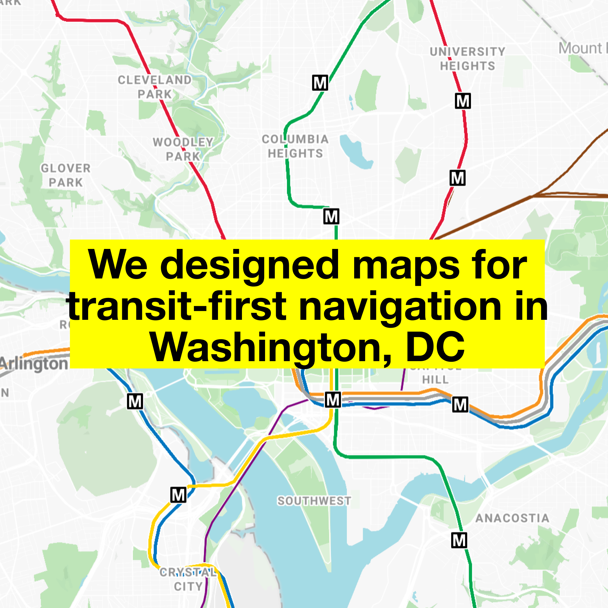
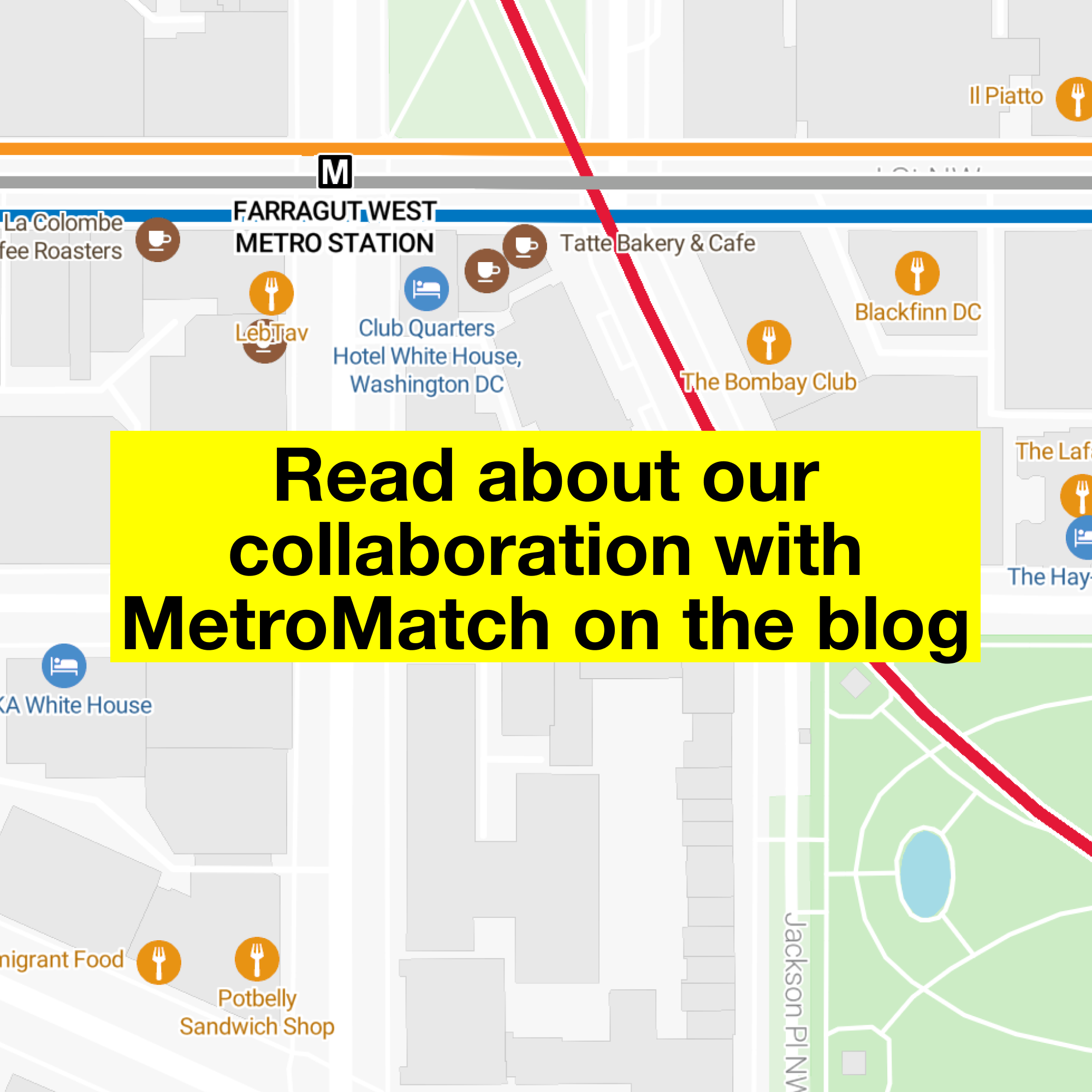
Stamen recently collaborated with MetroMatch, a transit-first navigation tool focused on identifying destinations within walking distance of transit in U.S. cities. Read about how we redesigned their map for Washington, DC on the blog.
https://stamen.com/navigate-your-city-car-free-with-metromatch/
#maps #design #cartography #transit #metro #dcmetro #OpenStreetMap #WashingtonDC
🌍𝐇𝐨𝐰 𝐜𝐚𝐧 𝐫𝐨𝐚𝐝 𝐬𝐮𝐫𝐟𝐚𝐜𝐞 𝐝𝐚𝐭𝐚 𝐡𝐞𝐥𝐩 𝐚𝐧𝐬𝐰𝐞𝐫 𝐛𝐢𝐠 𝐝𝐞𝐯𝐞𝐥𝐨𝐩𝐦𝐞𝐧𝐭 & 𝐡𝐮𝐦𝐚𝐧𝐢𝐭𝐚𝐫𝐢𝐚𝐧 𝐪𝐮𝐞𝐬𝐭𝐢𝐨𝐧𝐬?
📊 The tutorial shows how to combine our global road surface dataset with population data for Mozambique:
overlay road surface + population data
spot infrastructure gaps where many depend on poor/undocumented roads
explore data with open tools (DuckDB, Mercantile, Shapely)
👉 https://heigit.org/identifying-infrastructure-gaps-with-road-surface-dataset/
#GeoAI #OpenData #OpenStreetMap #Mapillary
Stamen and #OpenStreetMap through the years, part 3
https://stamen.com/part-3-our-brilliant-friend-stamen-and-openstreetmap-through-the-years/
Petite cartographie de l'hôtel Yyldyz à Achgabat !
ICYMI yesterday: I've been writing about the diversity of tools for contributing to #OpenStreetMap and how this diversity plays a role in creating and maintaining a healthy commons.
@[email protected] · Reply to Bastian Greshake Tzovaras's post
Had a blast at our little #OpenStreetMap birthday celebration. 🍰 🧉
It ended up being too windy to fly drones for long. Instead we recorded street-level images for #panoramax and GPS tracks, in addition to doing a lot of live surveying – using a huge range of tools that allow contributing to OSM!
In no particular order we at least used: @everydoor, @streetcomplete, @MapComplete, @CoMaps, HOTOSM's ChatMap, iD and JOSM.
Having so many different ways of making contributions is a real feature.
Completo fin de semana de instalaciones y mapeados, en el mundo del Software Libre, con la coincidencia en el tiempo del lanzamiento de Debian 13 y el 21 aniversario de OpenStreetMap. 🎉🎊
El ecosistema libre sigue avanzando. 🖥️🐧🗺️💻
#Debian #Debian13 #OpenStreetMap #Gnu #Linux #mapas #maps #SoftwareLibre #opensource
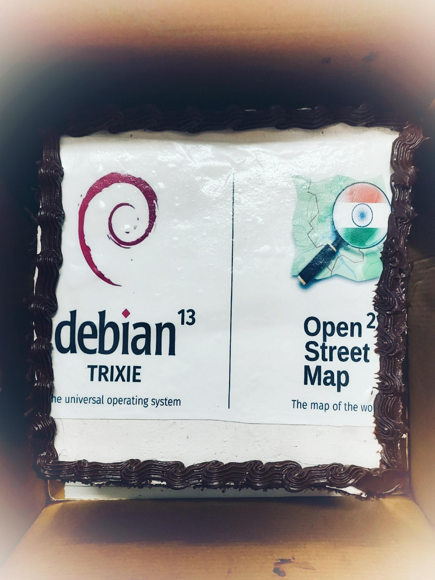
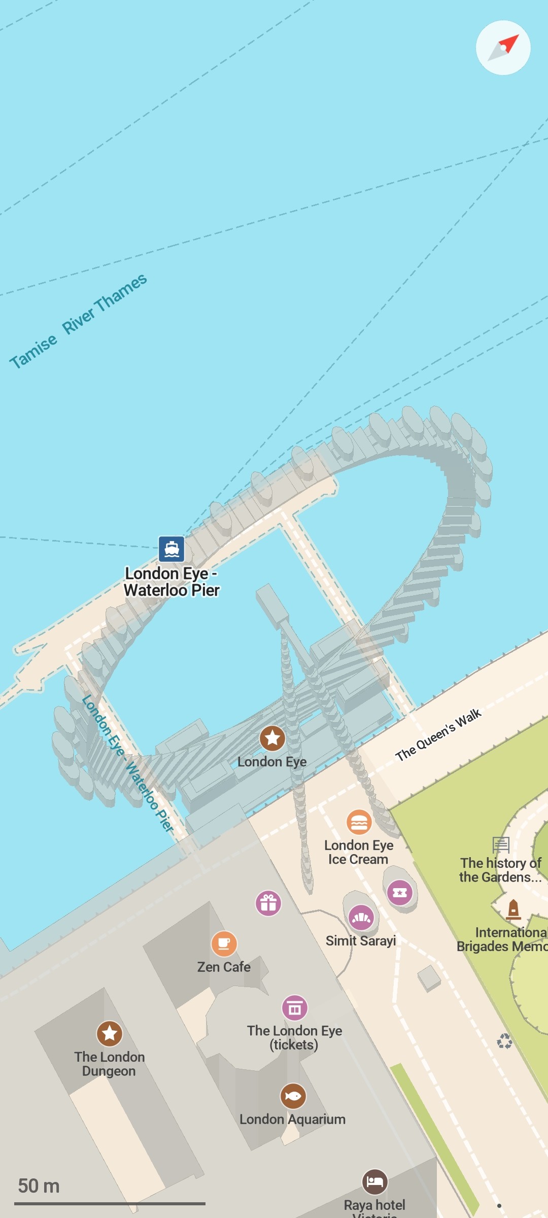
@[email protected] · Reply to CoMaps - Hike, Bike, Drive's post
@CoMaps A small anthology beautiful on CoMaps😍:
🗺️London Eye (tricky 3D model🤯)
51.5033411,-0.1196761
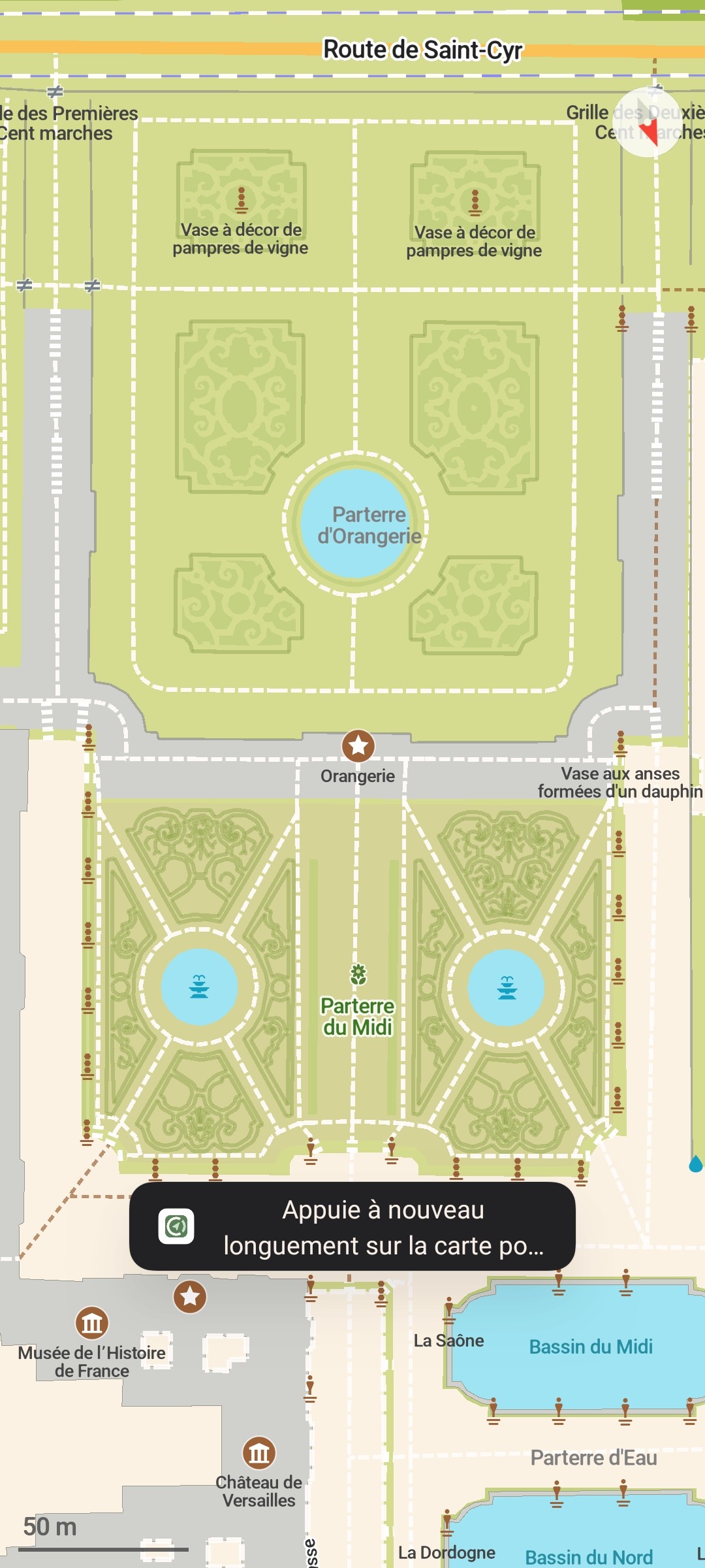
🗺️Versailles jardins, le Parterre du Midi
48.8037087,2.1193341
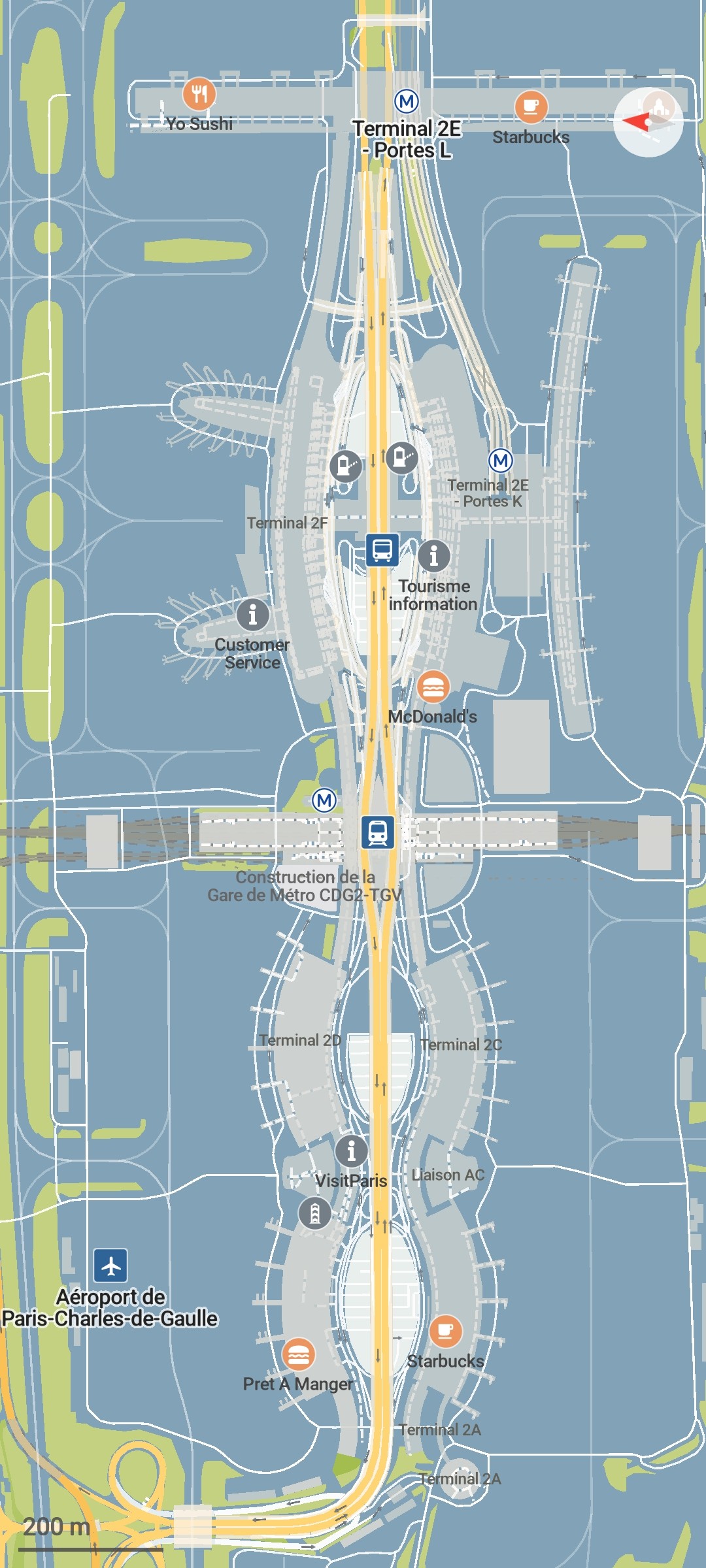
🗺️Charles-de-Gaulle Airport, Paris
5.2293208,-52.7729604
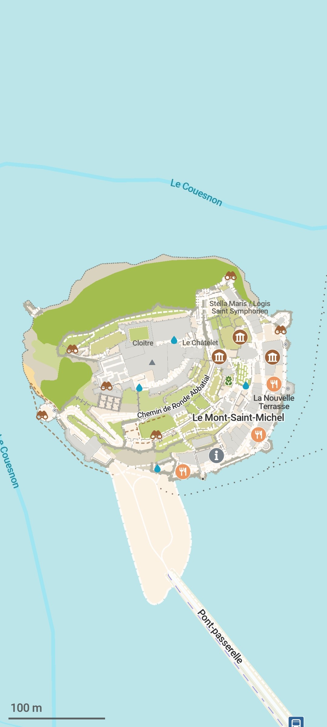
🗺️Le Mont Saint-Michel and its bay
48.6360206,-1.5114959
@[email protected] · Reply to Bastian Greshake Tzovaras's post
Had a blast at our little #OpenStreetMap birthday celebration. 🍰 🧉
It ended up being too windy to fly drones for long. Instead we recorded street-level images for #panoramax and GPS tracks, in addition to doing a lot of live surveying – using a huge range of tools that allow contributing to OSM!
In no particular order we at least used: @everydoor, @streetcomplete, @MapComplete, @CoMaps, HOTOSM's ChatMap, iD and JOSM.
Having so many different ways of making contributions is a real feature.
Happy 21st Birthday @openstreetmap! 🍰 🥳 🎈
Gonna meet up with friends to celebrate, do some on-the-ground surveying, probably also walk around with a 360° cam to get imagery for @panoramax. And fly a drone, to get some nice aerial imagery while we're at it! 🗺️ 📷
And of course have some cake too 😂
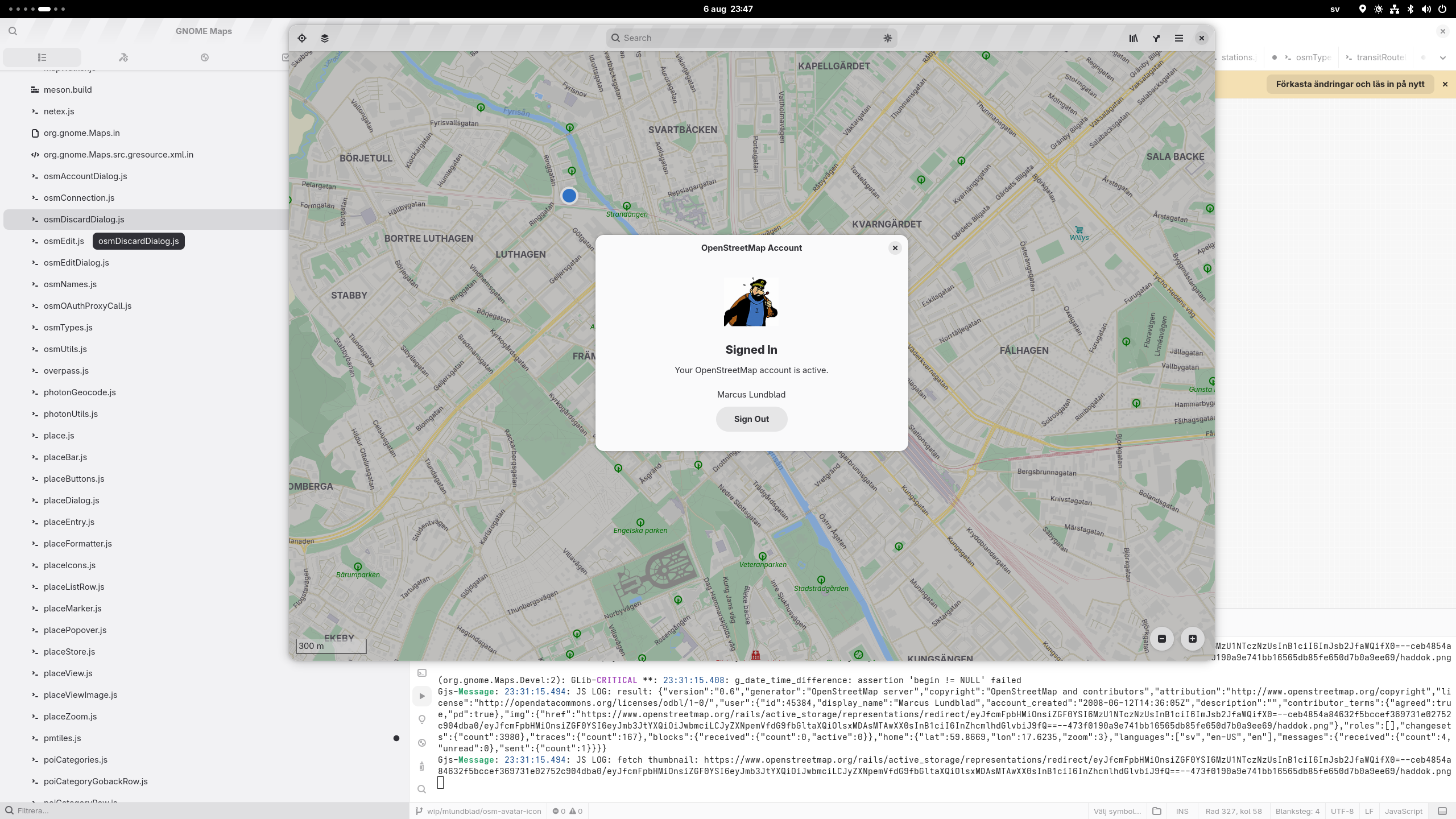
Implemented loading the user's account avatar, and displaying it in place of the "default user avatar" symbolic icon in the OpenStreetMap account setup dialog (for OAuth setup of your OSM account for editing POIs in Maps). After a suggestion by @pigeon_ about using the "user details" OSM JSON API.
Though, this will not be GNOME 49 material, as we're passed the UI freeze deadline by now…
@[email protected] · Reply to CoMaps - Hike, Bike, Drive's post
@CoMaps about trails: would it be possible to show trail numbers/names on CoMaps? Missed that recently, when hiking and checking paths during our holidays.
Thought such data was not on #openstreetmap , but it actually is. Didn't find a way to see that on the CoMaps screen, tho.
Any advice?
Je cartographie la capital du Turkménistan, Ashgabat, depuis un bon moment mais je n'ai pas encore montré ici les avant/après, voilà donc le premier de la série !
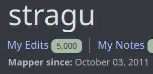
Celebrating 5000 changesets on #OpenStreetMap
Ho provato ad aggiungere un'attività commerciale nella mappa della mia città tramite la app @CoMaps , ma mi fa inserire solo la categoria e non altri dettagli (nome, indirizzo, orari). Qualcuno esperto di #OpenStreetMap mi può indicare dove sbaglio? #CoMaps
Ça fait une semaine que je contribue à #openstreetmap. Ce projet est génial. Je suis piqué par le virus de la cartographie !
"Je crois que cette zone avait besoin d'un peu de détail" be like !
Pour une fois c'est un avant/après en France !
As the next step after making road labels and markers directly clickable in Maps, maybe showing the road shield in details might be nice…
오픈스트리트맵에 명동찌개마을 지점이 매핑되고 있다. 회사에서 직접 하는 것 같은데, 이런 경우는 처음 봐서 신기하다.
주소랑 전화번호, 영업시간, 심지어 한식당이라는 정보까지 꼼꼼하게 매핑됐다. ㅋㅋ
changeset/168333299 changeset/168334088 changeset/168376461 changeset/168376685 changeset/168377067
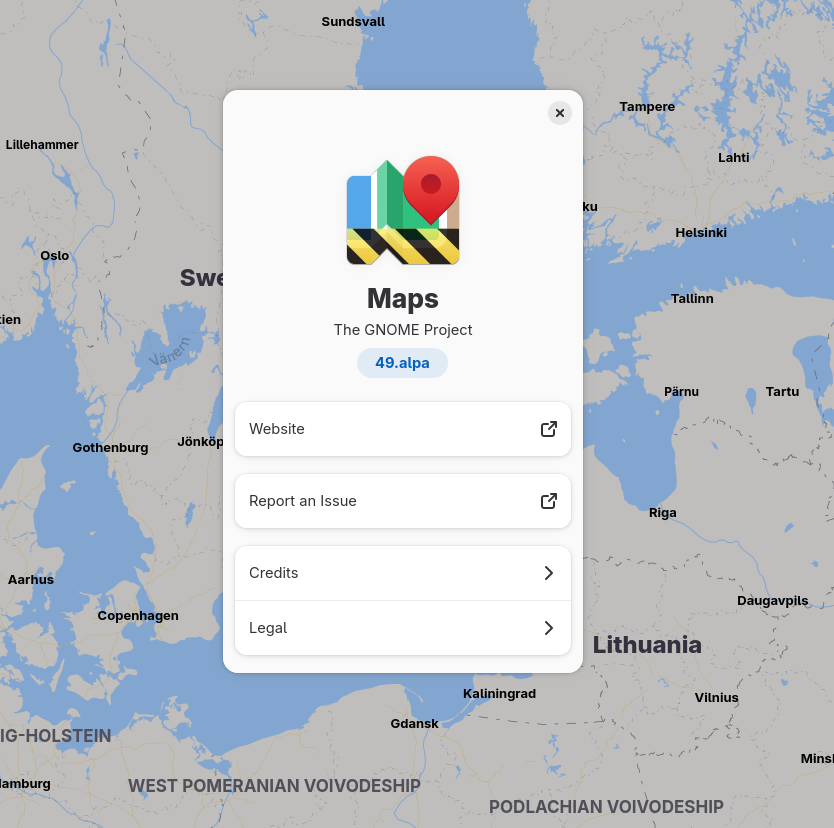
I forgot about the tarballs for the GNOME 49.alpha pre-release this Saturday…
But now they are out for Maps 49.alpha and libshumate 1.5.alpha anyway 😎
#gnomemaps #libshumate #Gnome #mapstondon #openstreetmap #gnome49
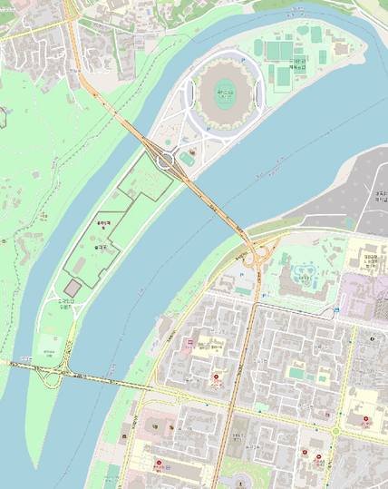
Carto de l'ile Rungna au cœur de Pyongyang.
Bon on voit pas très bien, mais regardez-moi cette belle cartounette https://www.openstreetmap.org/#map=16/39.04619/125.77342 !
Micromapped Saint Rose Dominican Hospital's Siena Campus in Las Vegas this week to hopefully provide better accessibility and orientation for patients and visitors.
Playing a bit with trying to implement indoor mapping support in libshumate (and ultimatly in Maps):
https://gitlab.gnome.org/GNOME/libshumate/-/tree/wip/mlundblad/indoor-levels
So far, one can manually edit a hard-coded value (in shumate/shumate-vector-renderer.c) and run the libshumate demo app, selecting the "OSM Liberty" map source alternative.
So, don't expect anything mature soon… 😄
#libshumate #gnomemaps #gnome #openstreetmap #mapstodon #indoormapping
🌍 Planet-wide OSM vector tiles, built with Planetiler + Shortbread + VersaTiles.
You can help us to squash quirks & polish the layers!
Demo → https://planetiler.versatiles.org/
Code → https://github.com/versatiles-org/planetiler-shortbread
#OpenStreetMap #GIS
New (Northern hemisphere) summer blog post on news in Maps
https://ml4711.blogspot.com/2025/06/midsommer-maps.html
Covering some new features, a bug fix by @flyingpimonster, and a new feature where I did some live user testing by @dmark 😎
New (Northern hemisphere) summer blog post on news in Maps
https://ml4711.blogspot.com/2025/06/midsommer-maps.html
Covering some new features, a bug fix by @flyingpimonster, and a new feature where I did some live user testing by @dmark 😎
This is Mahatshula, or North Mahatshula. A large, newer suburb.
Location: https://www.openstreetmap.org/#map=16/-20.11250/28.63569
A public agency here (Madison, WI, USA) is planning to collect street level imagery and give it to Google. I don't know what the details of the arrangement are, but I want to advocate for also releasing the data as #OpenData so that it can be used for #OpenStreetMap etc. Are there any good models I can mention? I remember the Vermont DOT partner, but that was a long time ago (maybe before the FB acquisition) https://vtrans.vermont.gov/working/videologs
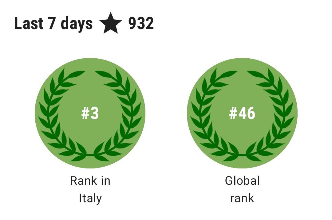
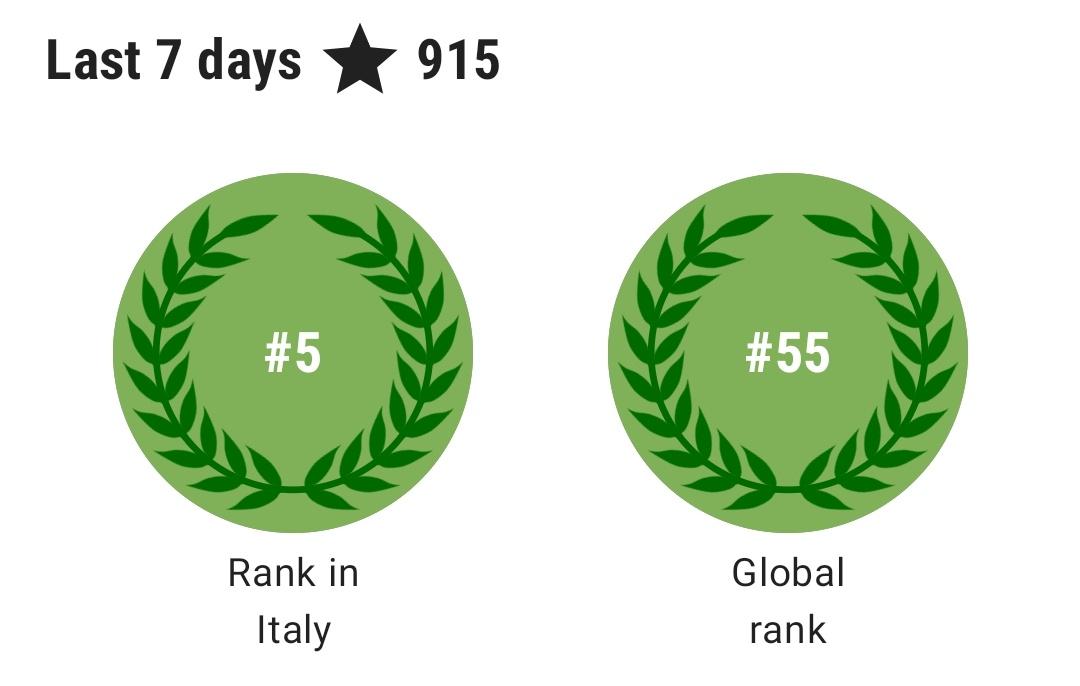
@[email protected] · Reply to Elias Probst's post
To be honest: I'm a little shocked how relatively little it takes, to climb that high in local and even global ranks.
I always assumed the top ranks are occupied by some ultra high-activity commercial mappers, group accounts etc., but this might be just a very thin layer on top.
Gibt es eine Oberfläche für den Desktop, am besten im Browser wo man gut eigene Karten mit #OSM #OpenStreetMap erstellen kann? #ask_fedi
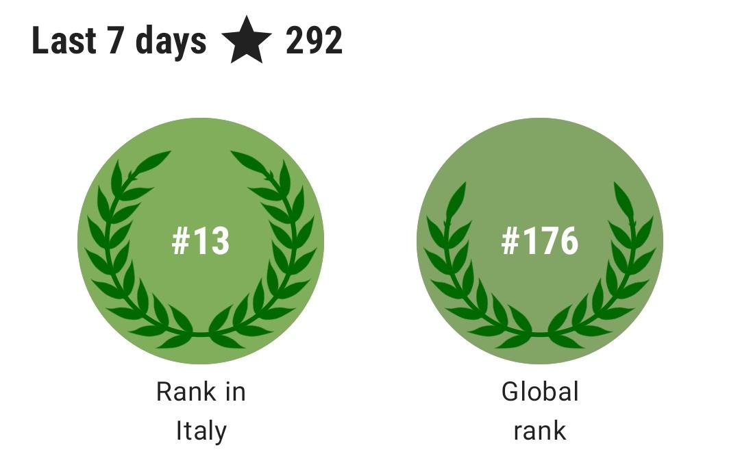
@[email protected] · Reply to Elias Probst's post
I'm not done yet!
Cartographie de l'ilot Tudan-do à Pyongyang
Est-ce qu'on doit appeler ça une ile, un ilot ou c'est aucun des deux ? (une presqu'ile ?)
오픈스트리트맵에서 폐쇄된 따릉이 대여소를 정리했다. 지도 데이터는 너무나 빨리 썩어버리지만 썩은 데이터를 골라내기는 너무 어렵다.
changeset/167490539, changeset/167490402, changeset/167490319, changeset/167490264, changeset/167489738, changeset/167489667, changeset/167489584, changeset/167488790
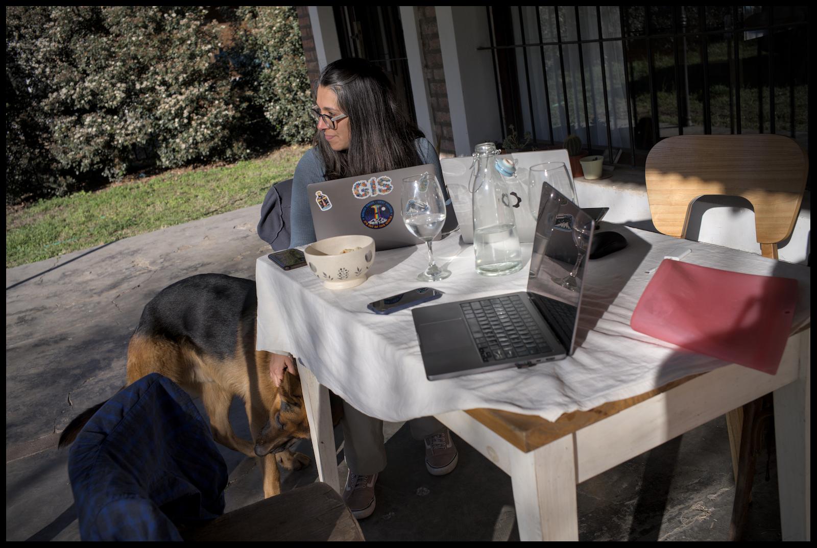
@openstreetmap @osm_tech @Firefishy I think we have to give credit where credit is due: #Openstreetmap and #GIS stuff in #Debian is as good as it is today because Sebastiaan Couwenberg does an amazing job as Maintainer of the Debian GIS Project.
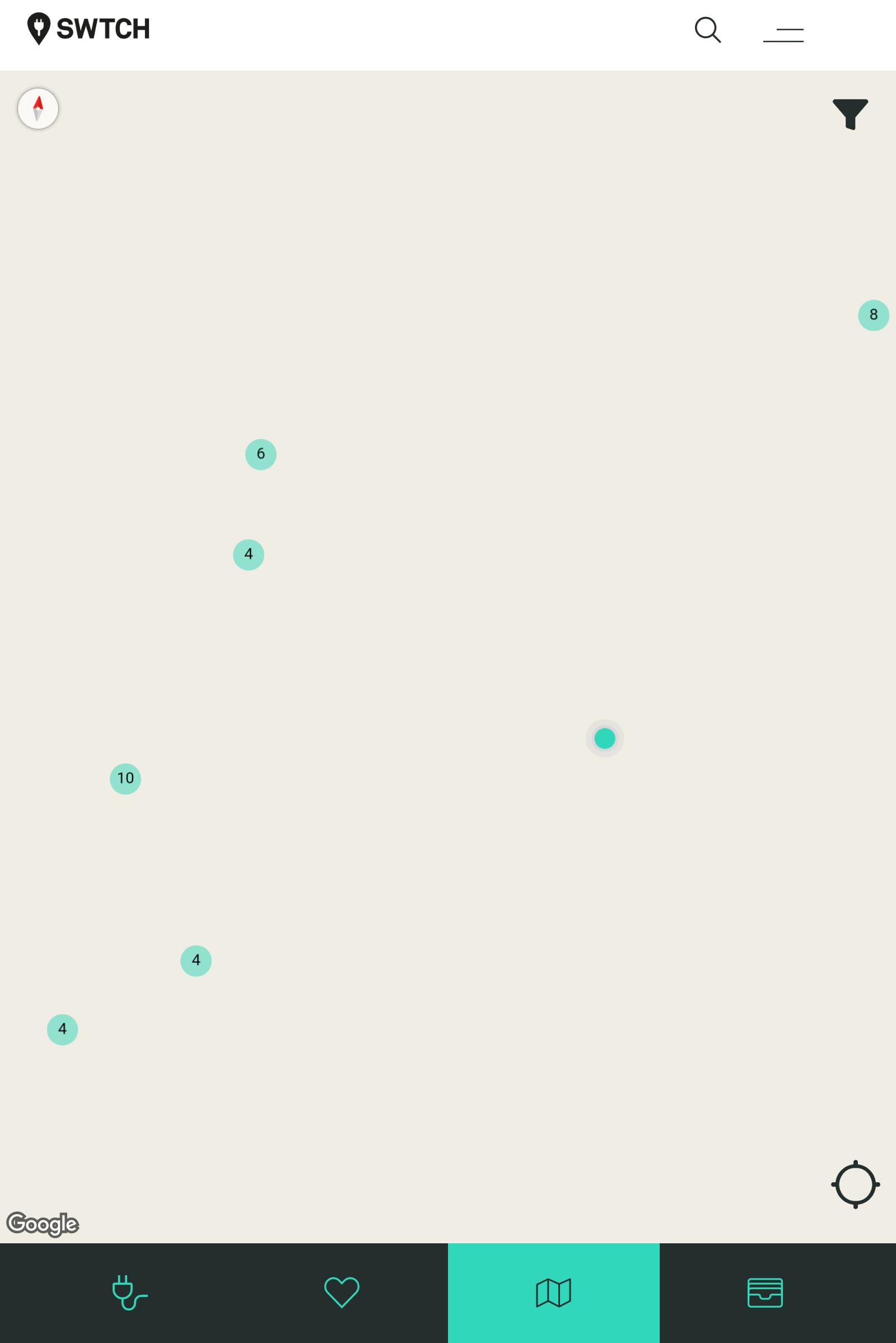
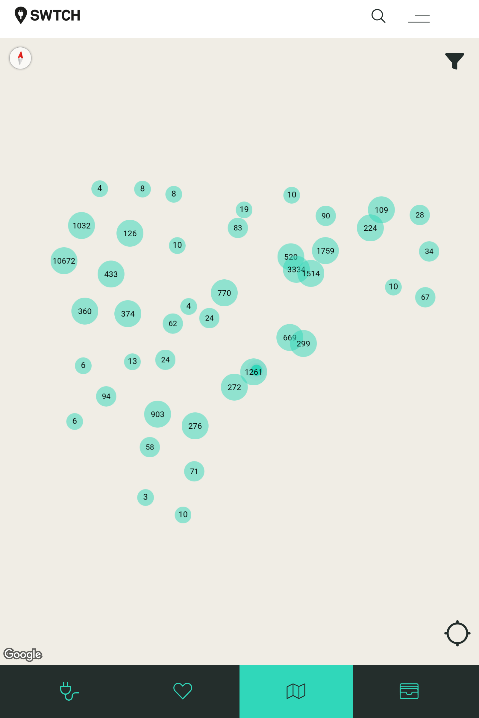
Adding EV charger details to #OpenStreetMap and not seeing the SWTCH brand come up. They seem big. Are they big enough to be a brand?
Project for today: add a bunch more houses to my parents town in #openstreetmap so I can streetcomplete them all with addresses etc. when I'm there! I really love rapid for this because it saves so much clicking.
The imagery issue, where big business is pulling all the satellite imagery is really frustrating. This is why that imagery needs to be in public hands to begin with. Rapid itself feels also like something that'll be pulled sooner rather than later. So I use it while I can.
Uiii! Selfe-made errors in OSMgo.org:
When your #OpenStreetMap tool draws an "division by zero", you need to investigate. I did, while coding #3D rendering. The cause was a way with two times the same node in sequence (not fist=last for closed ways). The distance is zero!
After inspecting an example:
The blamed way is not a way but a multi-polygon. Ways are concated. And the identical nodes at the end were the doubles %-I
And beside this: My code does not support multiple areas!
Well, there is always hope:
https://community.openstreetmap.org/t/all-new-3d-rendering-an-osm-building-inspector/131091
Pour ce gif je suis assez fière du travail réalisé, c'est la ville de Chongdan-up à l'ouest d'une large zone que j'ai pas mal cartographié !
Finished micromapping Governors Island in New York a few days ago!
For anyone curious, I used a combination of Bing and NYS Orthos Online aerial imagery. The footpaths in the older areas came from a 1960’s US Department of Engineers tree survey map that had the island drawn in great detail. The rest of the information came from wikipedia articles and wikimedia + other license compatiable images. This resulted in 37,376 changes and a lot of hours of work
Just tried #OpenFoodFacts for the first time.
It's like #OpenStreetMap but for food products.
The product editing UI is surprisingly good; well done!
By the way, I guess the icon for "Directions" should probably be pointing to the left in regions with left-hand road traffic… 😀🛣️🧭
#mapstodon #lefthandtraffic #gnomemaps #gnome #openstreetmap #attentionToDetail
France Becomes First Government to Endorse UN Open Source Principles, Joined by 19 Organizations
https://unite.un.org/fr/news/france-becomes-first-government-endorse-un-open-source-principles-joined-19-organizations
The United Nations Open Source United community is proud to announce a major milestone: The Government of the French Republic Opens a new window became the first national government to endorse the UN Open Source Principles.
#OpenSource #FreeSoftware #ONU #UN #France #CreativeCommons #Drupal #FDroid #ow2 #wordpress #xwiki #osm #openstreetmap
Petit carto à côté d'un lac et autour d'un monument.
Great news from the @sovtechfund - the German gov agency for #sovereigntech invests 384.000 euro in #OpenStreetMap. This is the Wikipedia of the maps and the basis for so many mapping and navigation tools.
Well done. So much needed to leave bigtech surveillance tech.
Great news from the @sovtechfund - the German gov agency for #sovereigntech invests 384.000 euro in #OpenStreetMap. This is the Wikipedia of the maps and the basis for so many mapping and navigation tools.
Well done. So much needed to leave bigtech surveillance tech.
Great news from the @sovtechfund - the German gov agency for #sovereigntech invests 384.000 euro in #OpenStreetMap. This is the Wikipedia of the maps and the basis for so many mapping and navigation tools.
Well done. So much needed to leave bigtech surveillance tech.
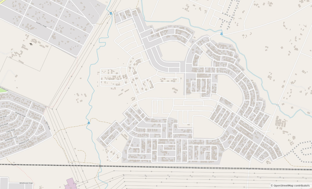
First time micromapping in Kazakhstan! Thanks @Koreller for the inspiration <3
Making more things directly “clickable” in Maps, like streets…
Another idea as a follow-up on this to add functionallity to the highway shield library to be able to get a paintable object given a place' network tags. So that we could show that instead of the generic “car” icon for roads when available.
P'tite carto d'un bout d'truc.
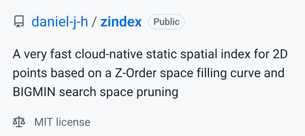
last week #zbush — this week the same technique as a cloud-native spatial index 🔥
https://github.com/daniel-j-h/zindex
hey #Mapstodon #OpenStreetMap #Geo what if we could use a single remote file as a cloud-native spatial index: With a Z-Curve and the BIGMIN optimization i haz it 😍
more context here: https://www.openstreetmap.org/user/daniel-j-h/diary/406584
help me test and refine it? 🌍
OpenStreetMap migrates to Debian 12: You may have seen this toot
announcing OpenStreetMap's migration to Debian on their infrastructure.
🚀 After 18 years on Ubuntu, we've upgraded the
@openstreetmap servers to Debian 12
(Bookworm). 🌍 openstreetmap.org is now faster
using Ruby 3.1. Onward to new mapping adventures! Thank you to the team for
the smooth transition.
#OpenStreetMap
#Debian 🤓
We spoke with Grant Slater, the Senior Site Reliability Engineer for the… https://bits.debian.org/2024/11/openstreetmap-on-debian.html
Athens is super well mapped on OpenStreetMap, the acropolis too!
In the past 4 days I have been moving around by using @organicmaps only 💕
#OpenStreetMap #OSM #Fairphone #Athens #acropolis #Greece #maps #OrganicMaps

Petit coloriage d'hier ☺️
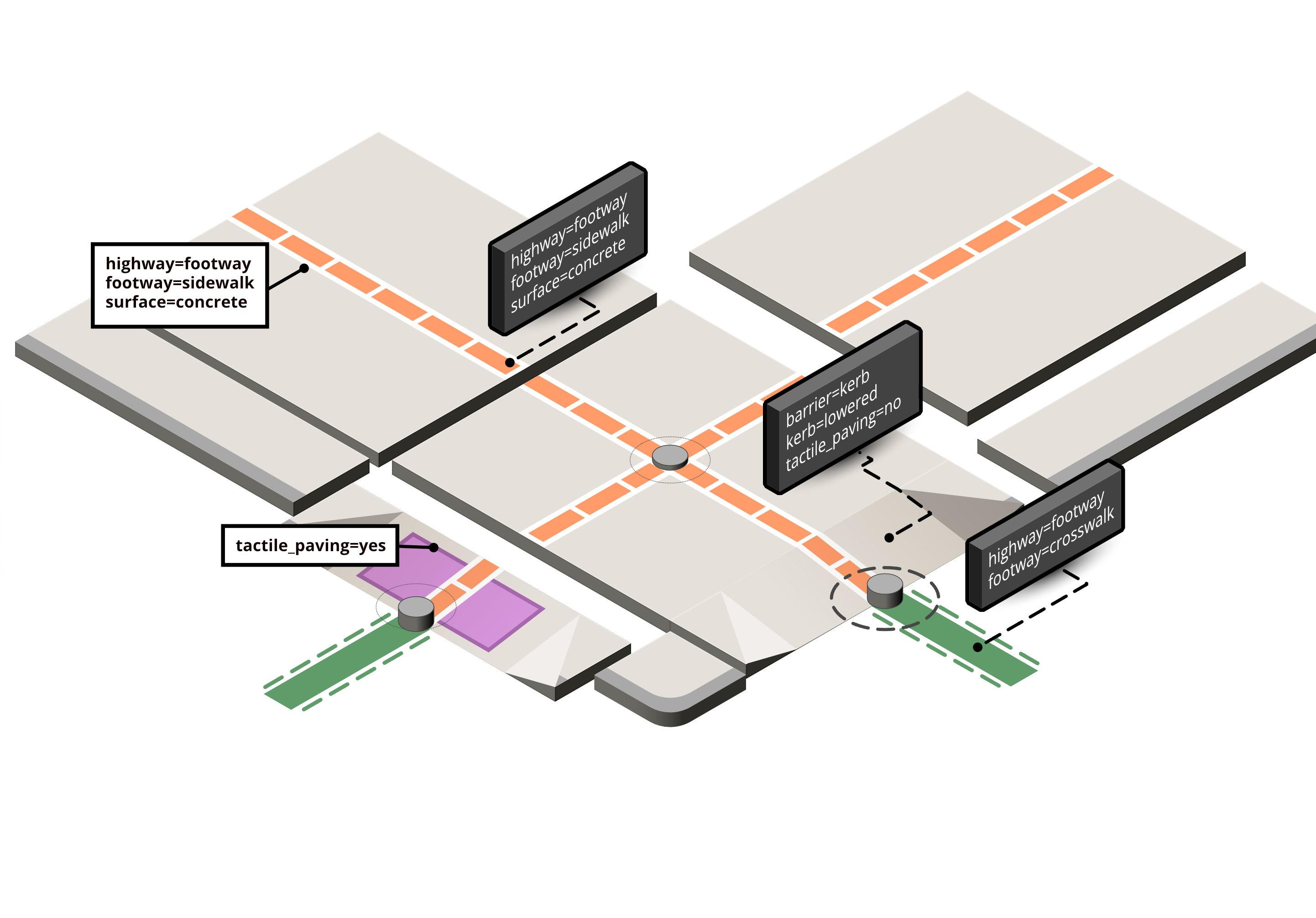
🚶♂️ Work in progress!
I’m exploring modular illustrations as visual aids to support #OpenStreetMap contributors and documentation. The modules can be mixed and matched to visualize diverse scenarios for sidewalks, curbs, and crossings.
Early test below. Feedback welcome!
Petit coloriage d'hier ☺️
Cartographie dont je suis assez content. Le avant après est assez saisissant 😁. C'est dans la campagne nord-coréenne, dans le sud du pays dans l'arrondissement de Chongdan, dans et autour du village de Hongsan-ri.
suggested adding an option to autogenerate changeset comments in #ideditor like done in @everydoor or @streetcomplete
wondering what other #openstreetmap users think about that #osm
🚶♂️ Work in progress!
I’m exploring modular illustrations as visual aids to support #OpenStreetMap contributors and documentation. The modules can be mixed and matched to visualize diverse scenarios for sidewalks, curbs, and crossings.
Early test below. Feedback welcome!
Ajout du village de Sokdam dans la campagne nord-coréenne.
Experimenting with showing custom icons for stations. Inspired a bit from our highway shield rendered (derived from OpenStreetMap Americana)
https://gitlab.gnome.org/GNOME/gnome-maps/-/tree/wip/mlundblad/station-icons
It's making use of the "network:wikidata" OSM tag.
Currently rendering these icons in map view itself is not tested (this needs an extra addition to our planetiler generator for the vector tiles to be run in the next import).
#gnomemaps #gnome #Transit #tunnelbana #mapstodon #openstreetmap
Ma cartographie des 7 derniers jours.
Et la dernière image c'est la vue d'ensemble de la zone amélioré. Avez-vous trouvé où le deuxième GIF se trouve ? 😜
오픈스트리트맵 위키의 초보자 길라잡이 목록을 최신화 했다. Node가 마디로 번역되었다던가 이상한 부분이 있다고 생각하지만 일단은 기존 번역어를 유지하는 걸로.. 🙁 OSM 프로젝트에 깊이 관여하지 않다 보니 전에 결정된 내용을 바꾸기 부담스럽다.
오픈스트리트맵 위키의 초보자 길라잡이 목록을 최신화 했다. Node가 마디로 번역되었다던가 이상한 부분이 있다고 생각하지만 일단은 기존 번역어를 유지하는 걸로.. 🙁 OSM 프로젝트에 깊이 관여하지 않다 보니 전에 결정된 내용을 바꾸기 부담스럽다.
오픈스트리트맵 위키의 초보자 길라잡이 목록을 최신화 했다. Node가 마디로 번역되었다던가 이상한 부분이 있다고 생각하지만 일단은 기존 번역어를 유지하는 걸로.. 🙁 OSM 프로젝트에 깊이 관여하지 않다 보니 전에 결정된 내용을 바꾸기 부담스럽다.
#sotm2024 yesterday Michael Montani introduced to #validation tools to improve #openstreetmap #opendata and #mappers skills based on the specific #unmaps #mooc course about it https://mappers.un.org/learning
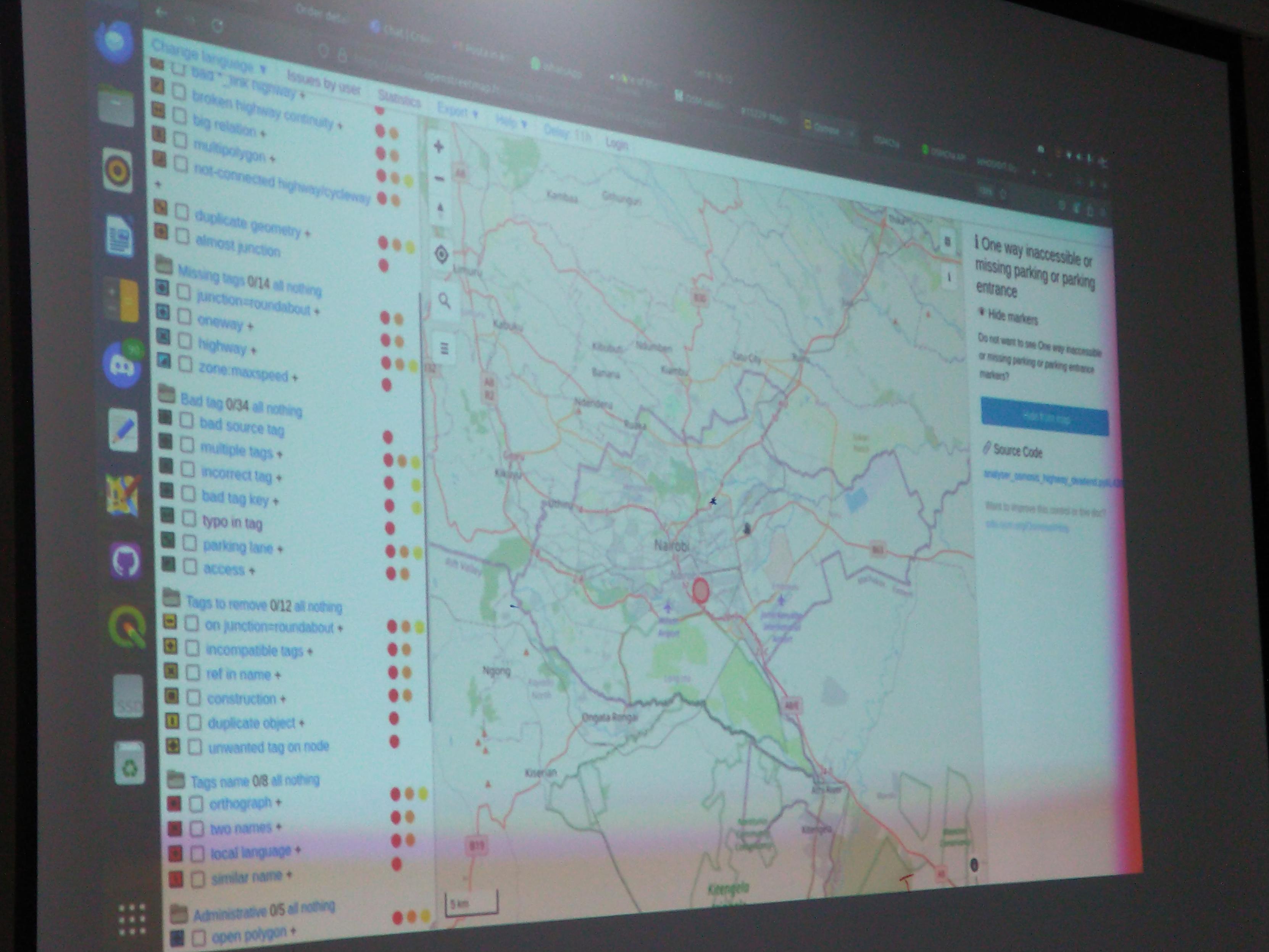
#sotm2024 yesterday Anastazia Caroll told her journey as a #womanintech, how she went beyond her fears of not being technical enough to embrace #geomatics and #openstreetmap and how she enjoyed to improve her skills and being able to deliver strong products now
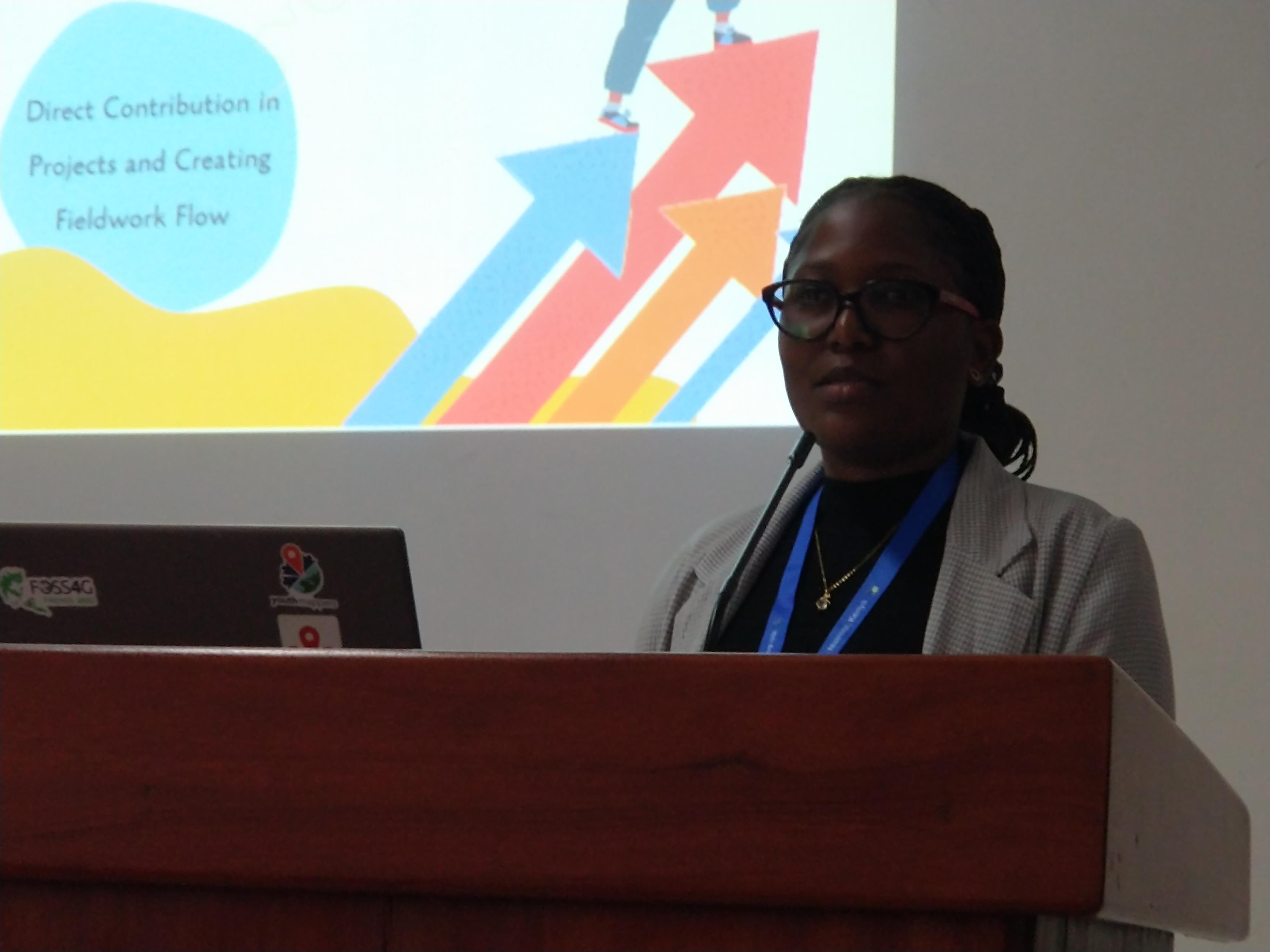
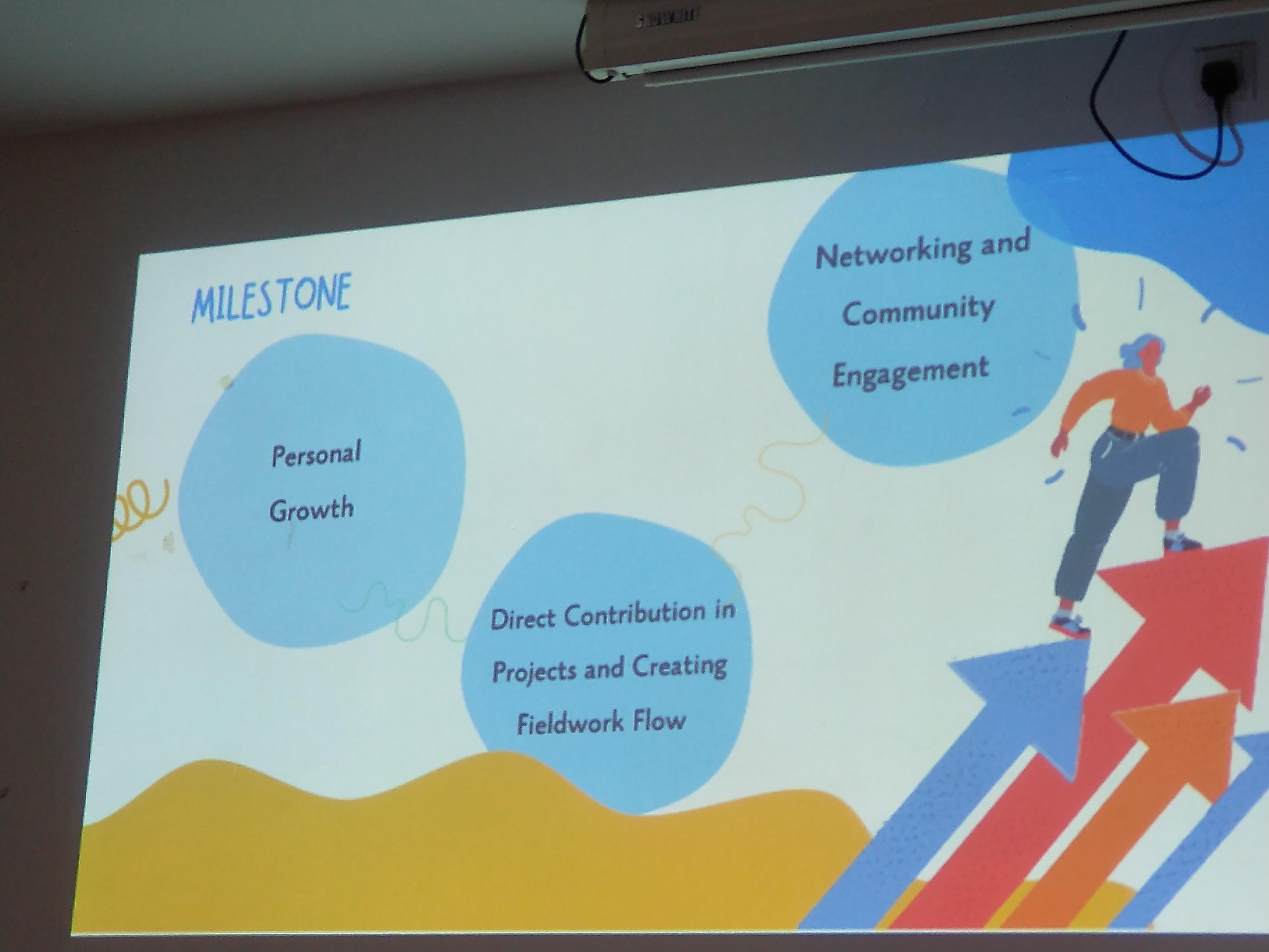
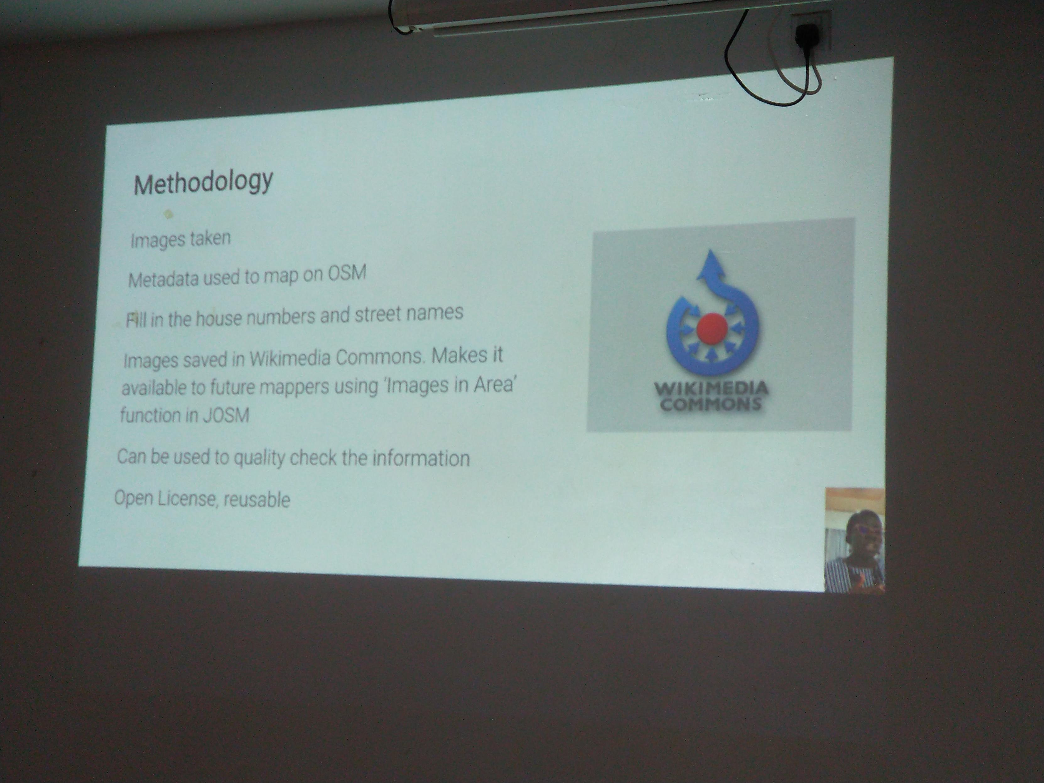
#sotm2024 yesterday Yvonne Darko told how she organized a street views collection in her village to map pharmacies and addresses in #openstreetmap. I like she used #wikicommons to host the pictures
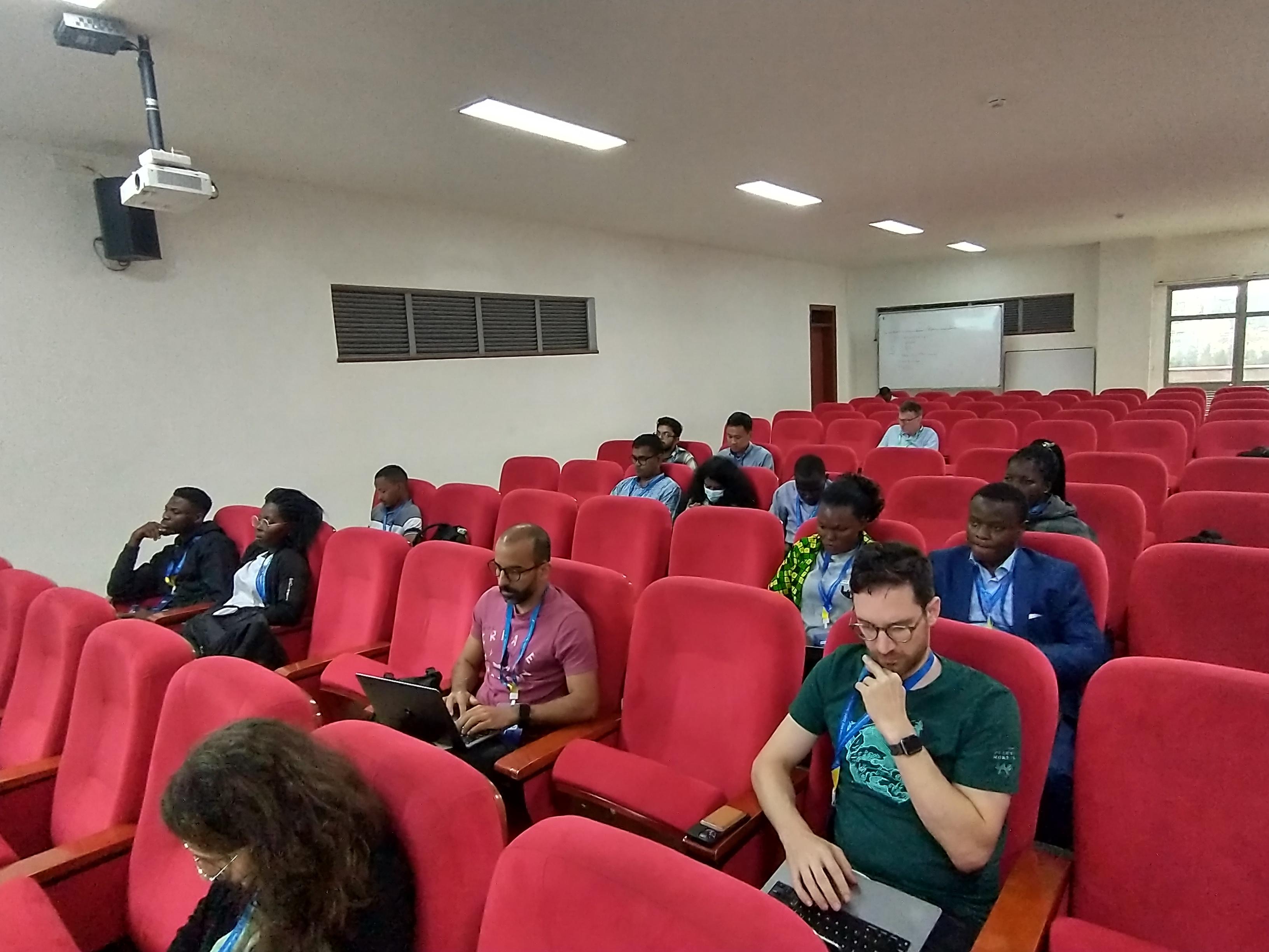
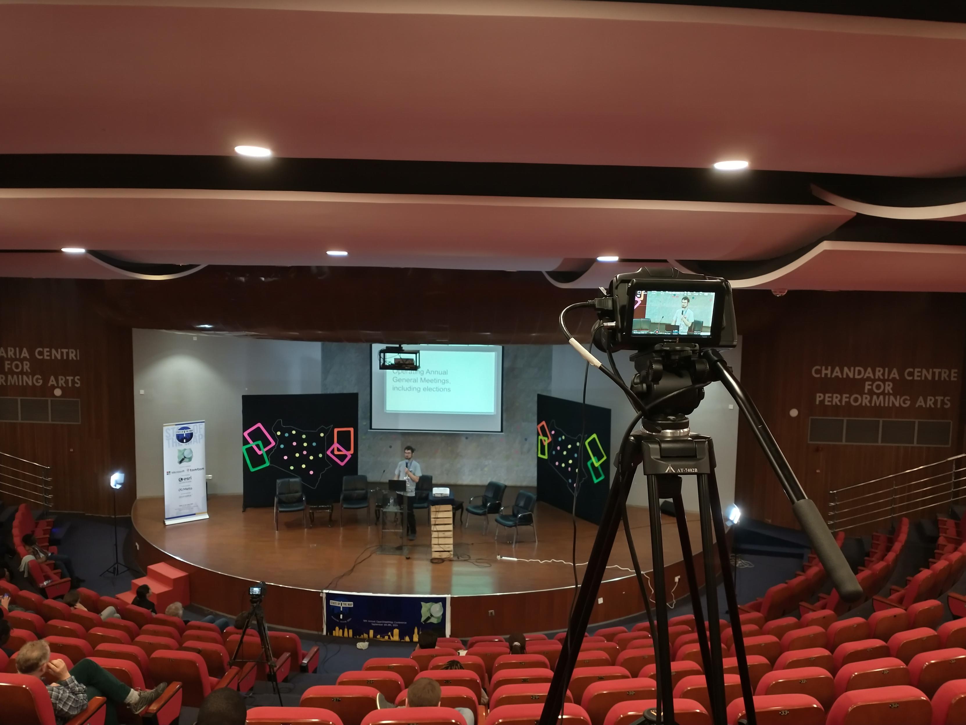
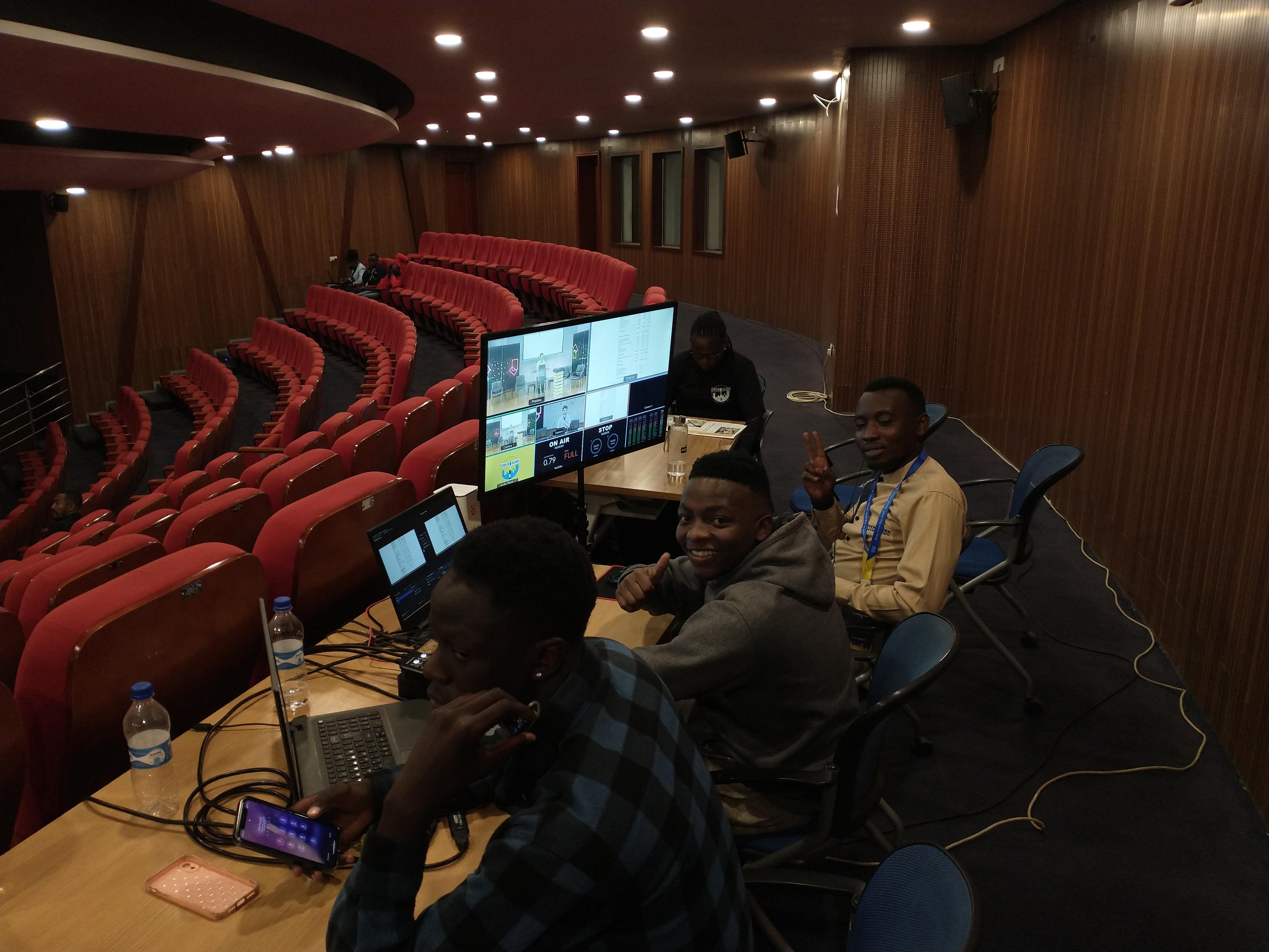
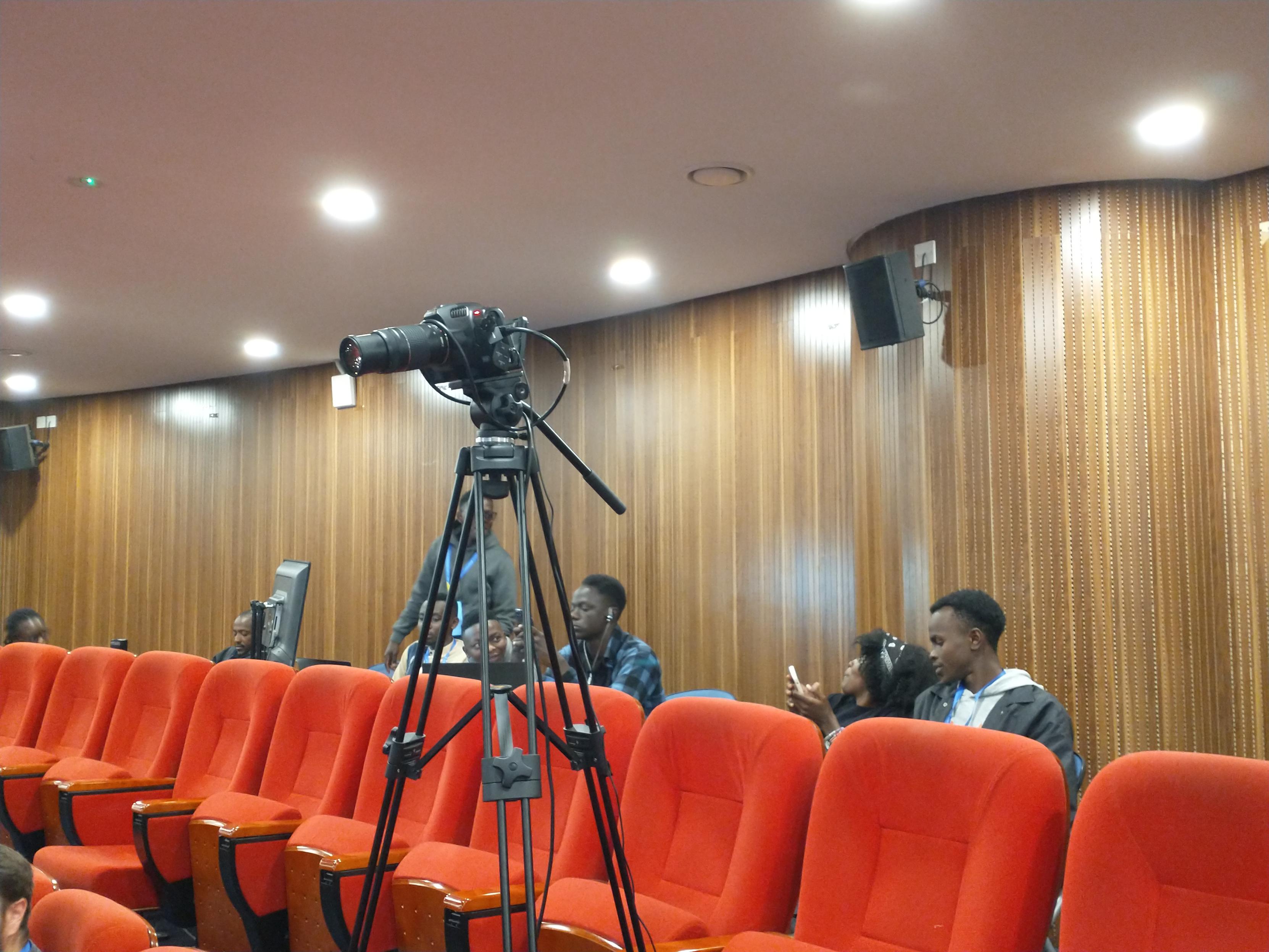
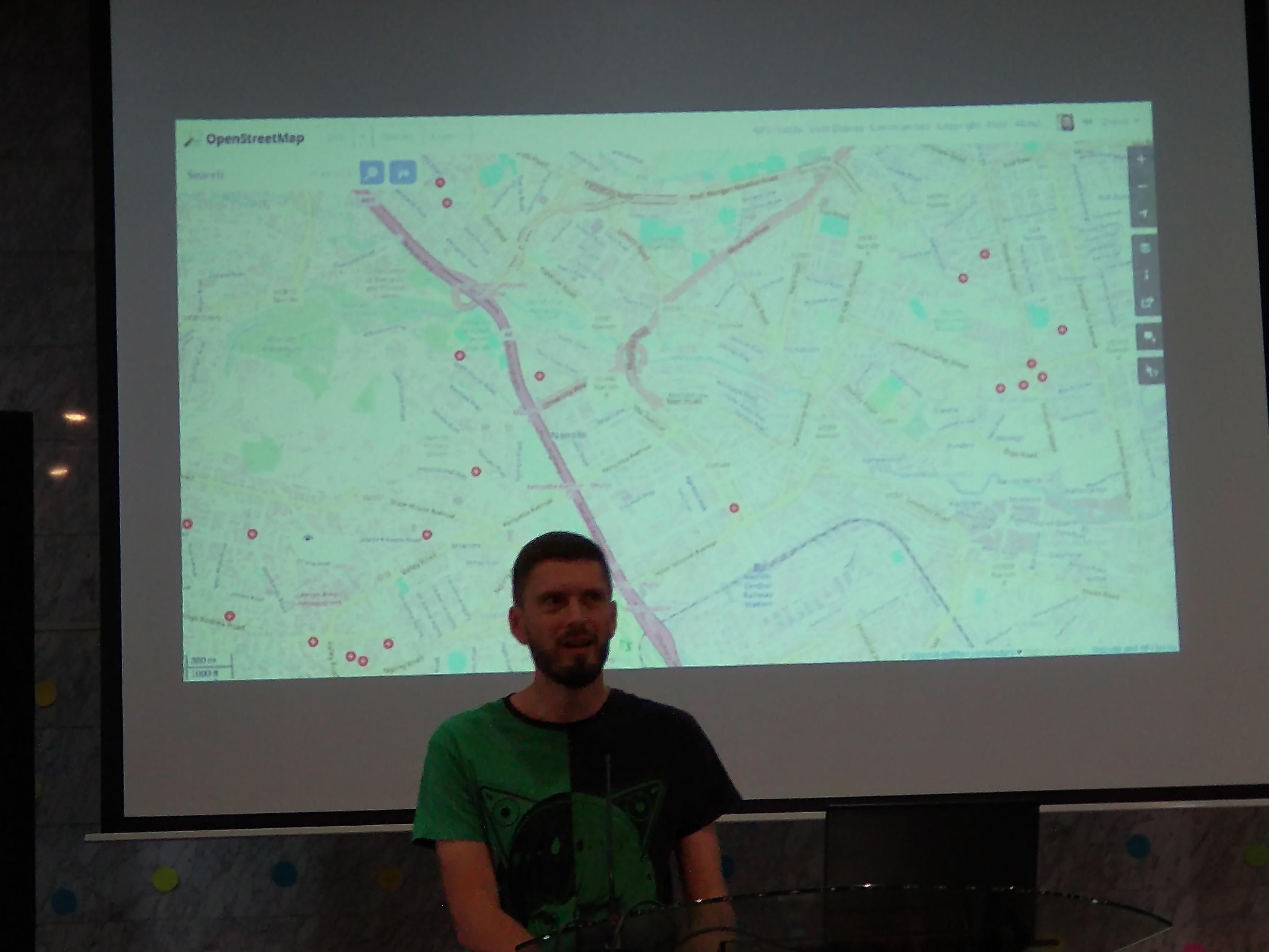
#sotm2024 thanks to the local technical team broadcasting the event from #nairobi to the remote #openstreetmap #community!
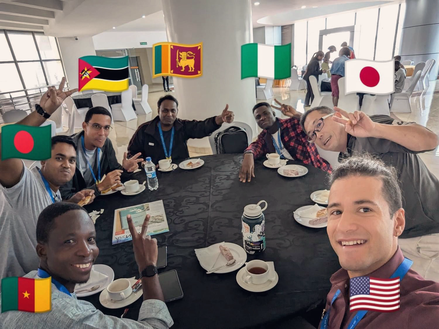
Members from diverse countries gather around the table to discuss cutting-edge geospatial technology.
#sotm #sotm2024 #OpenStreetMap #Nairobi #FuruhashiLab #古橋研究室
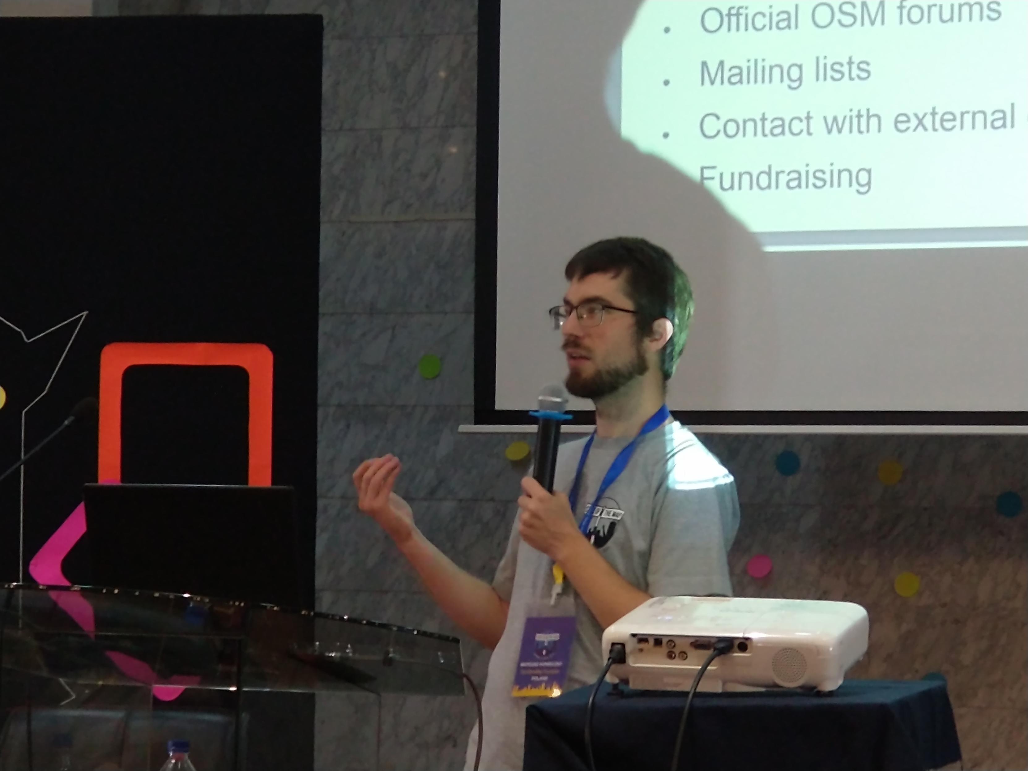
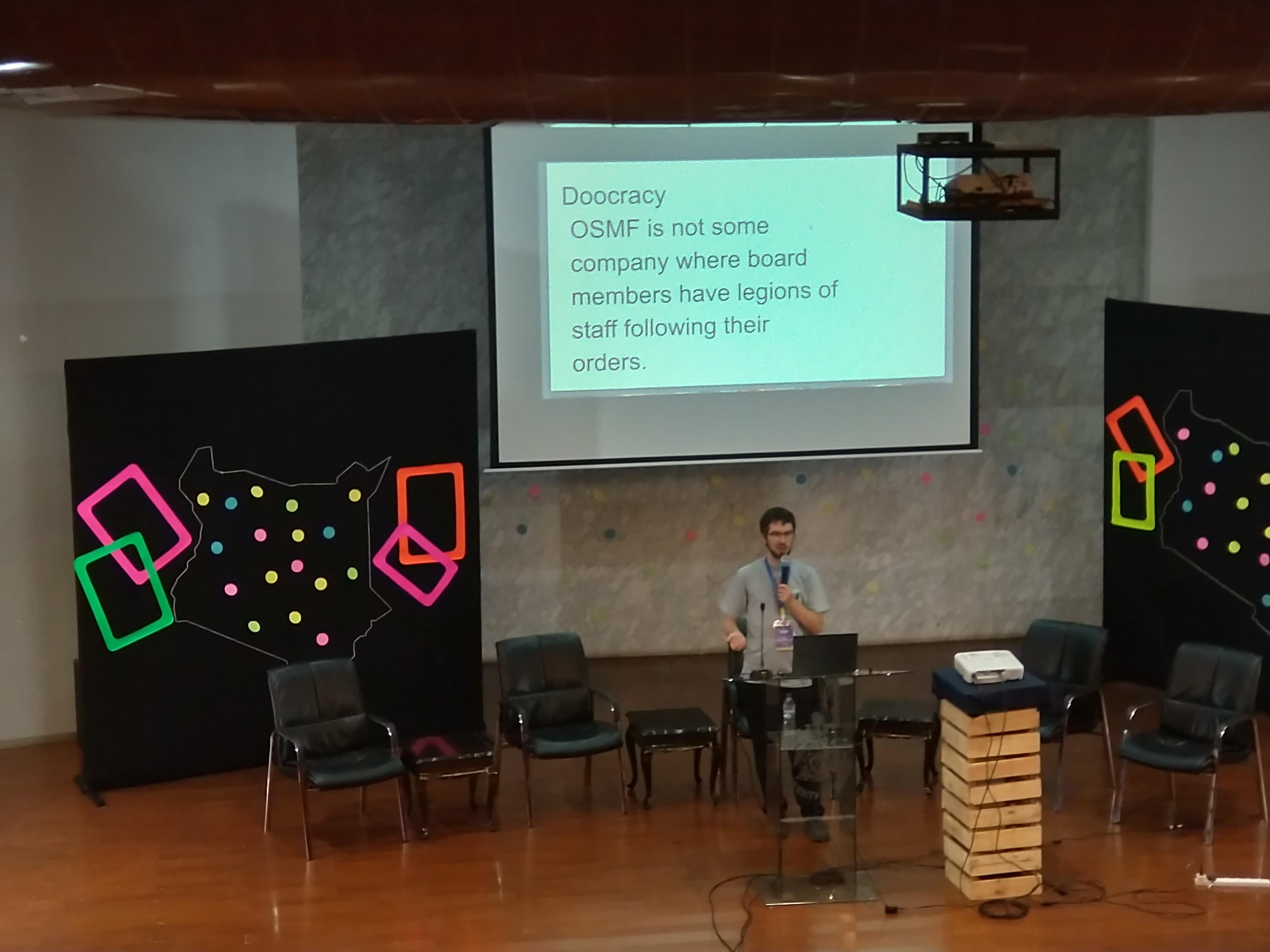
#sotm2024 Mateusz Konieczny presenting all what the #osmfoundation does to support without controlling the #openstreetmap #opendata and its vibrant #community
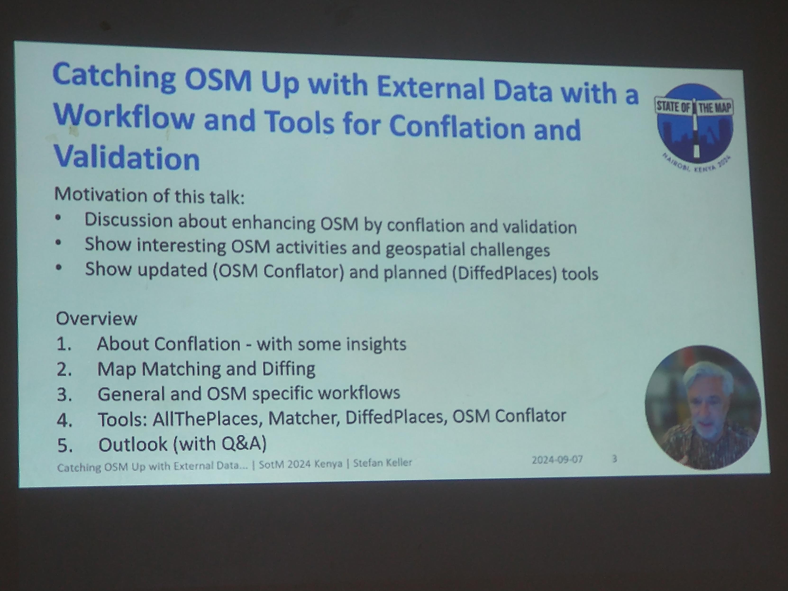
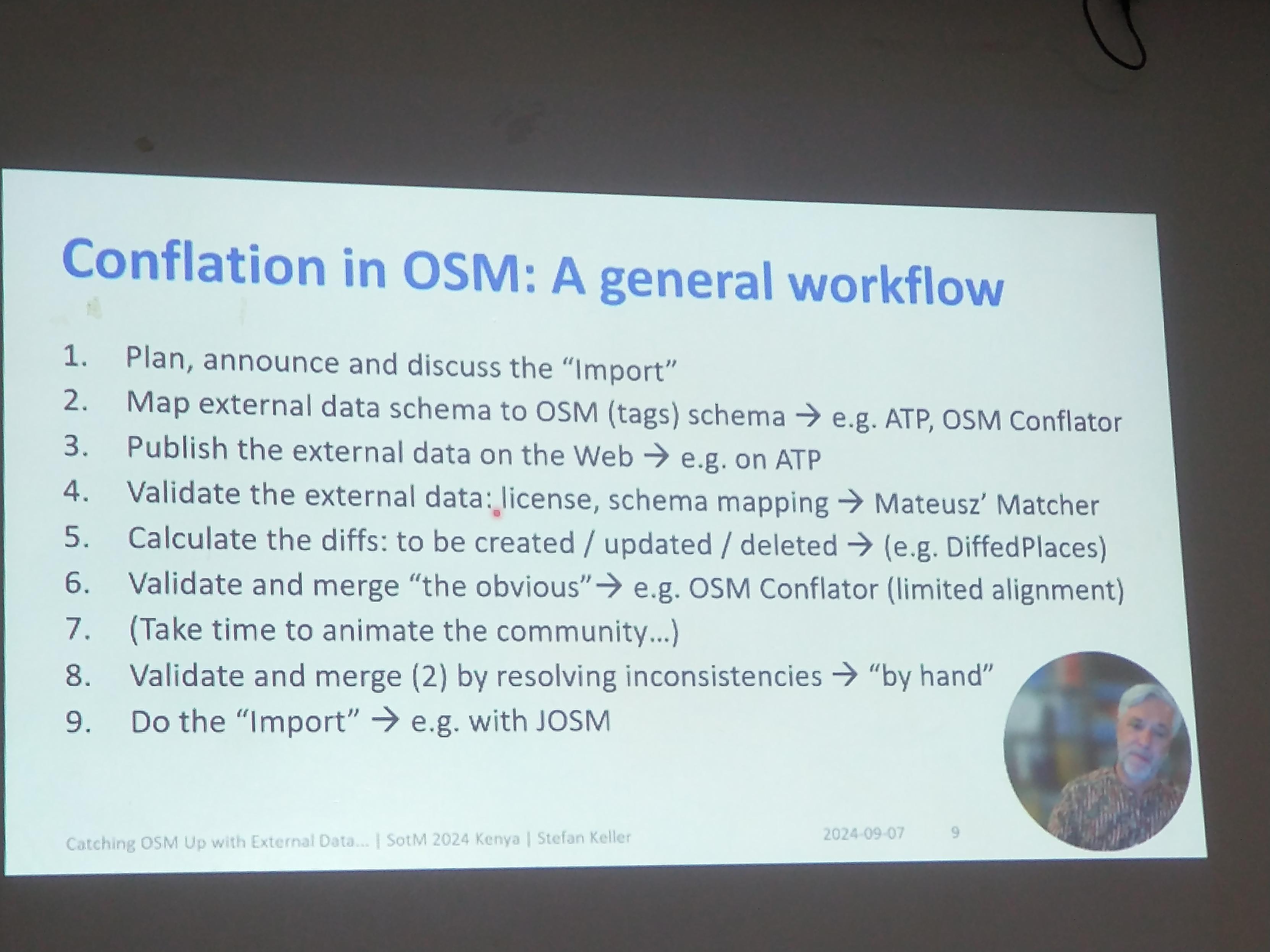
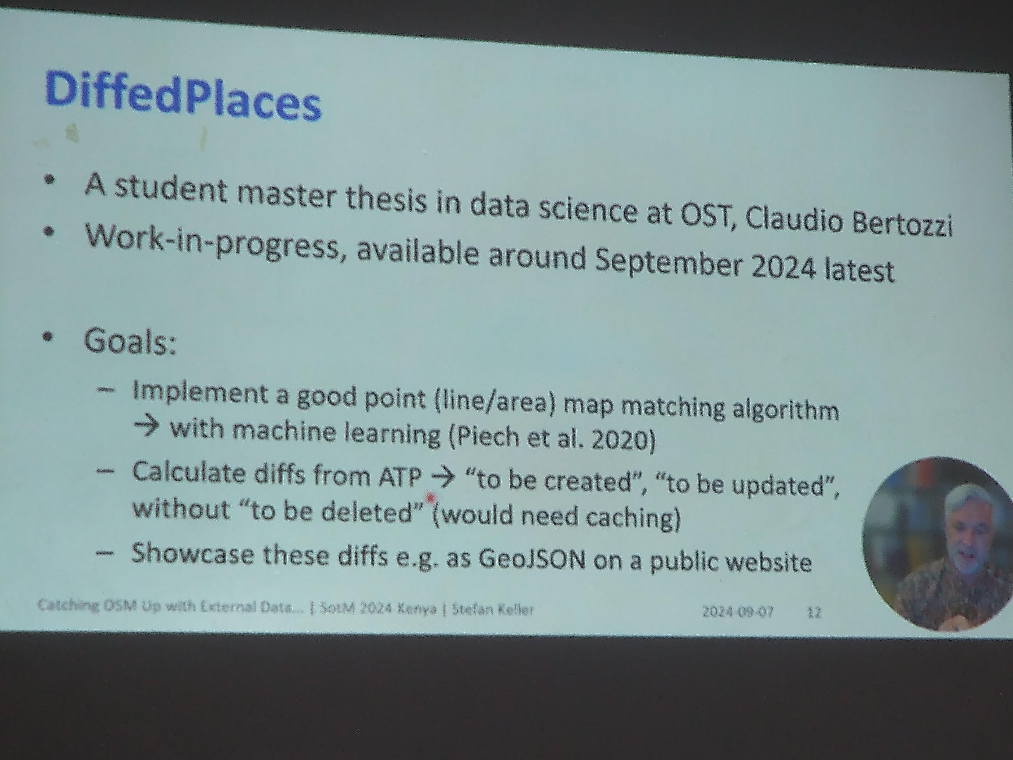
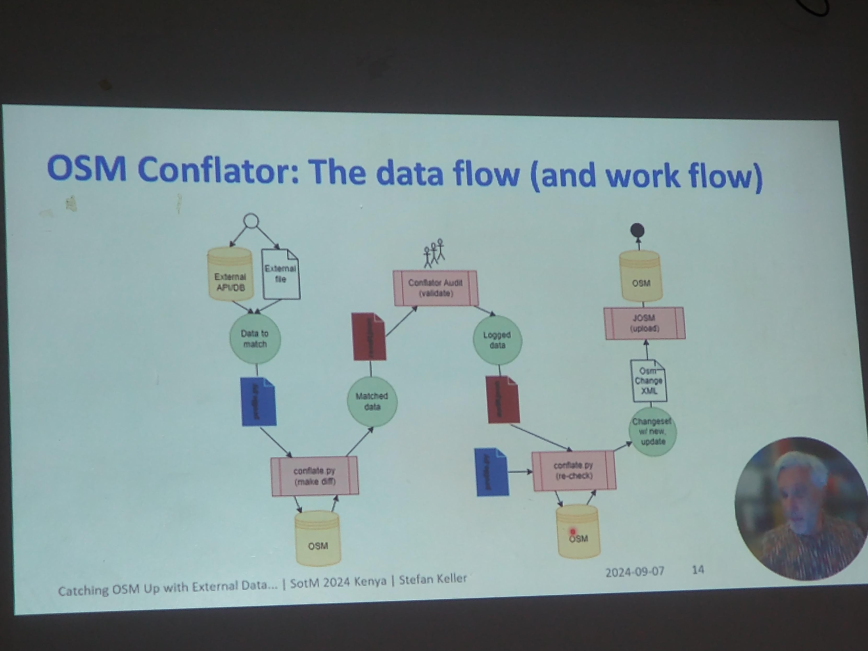
#sotm2024 Stefan Keller presenting ongoing research on #opendata #conflation in #openstreetmap introducing #diffedplaces created by Claudio Bertozzi and an improved forked version of #osmconflator
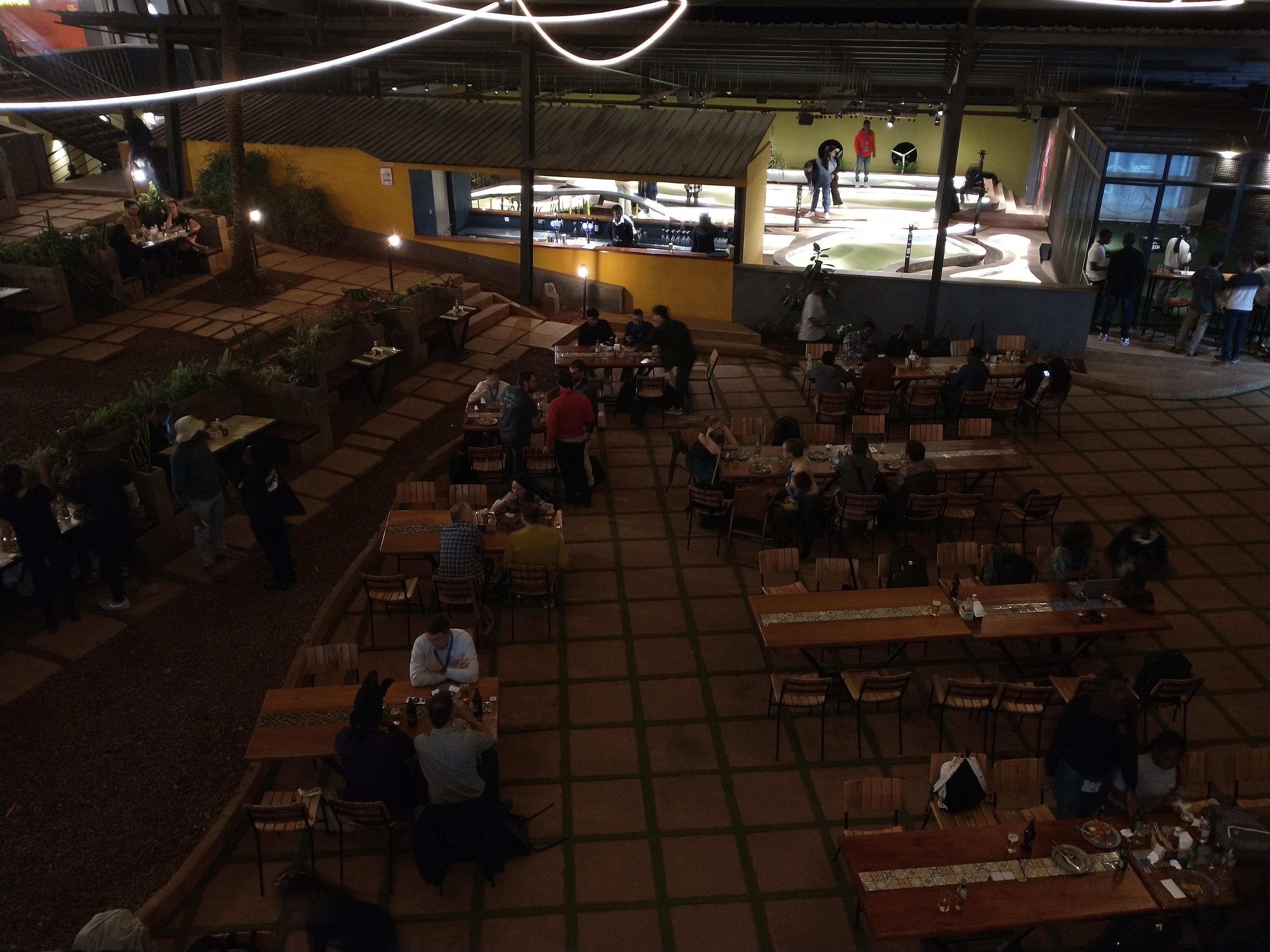
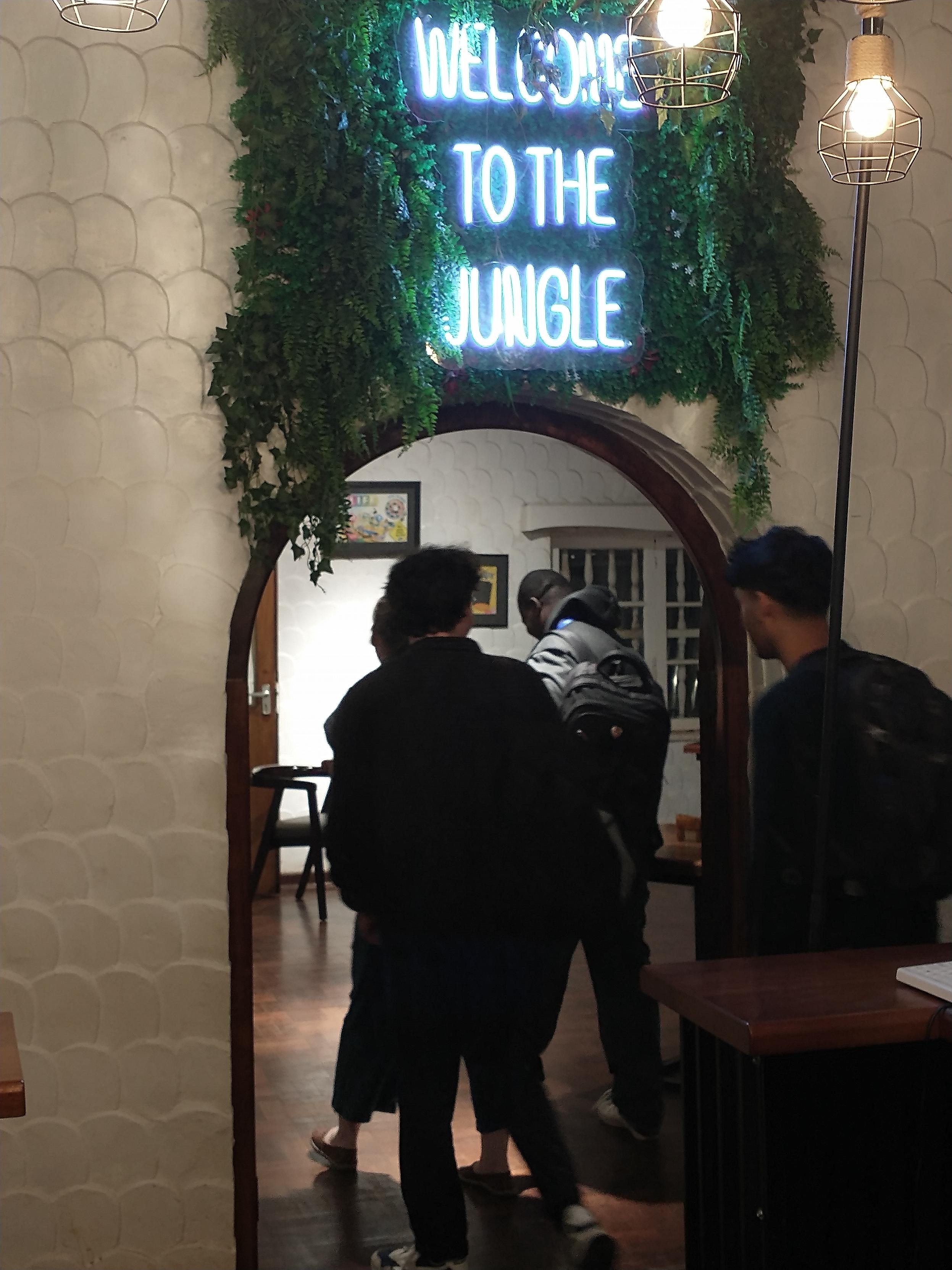
#Sotm2024 #openstreetmap social event at Bao Box

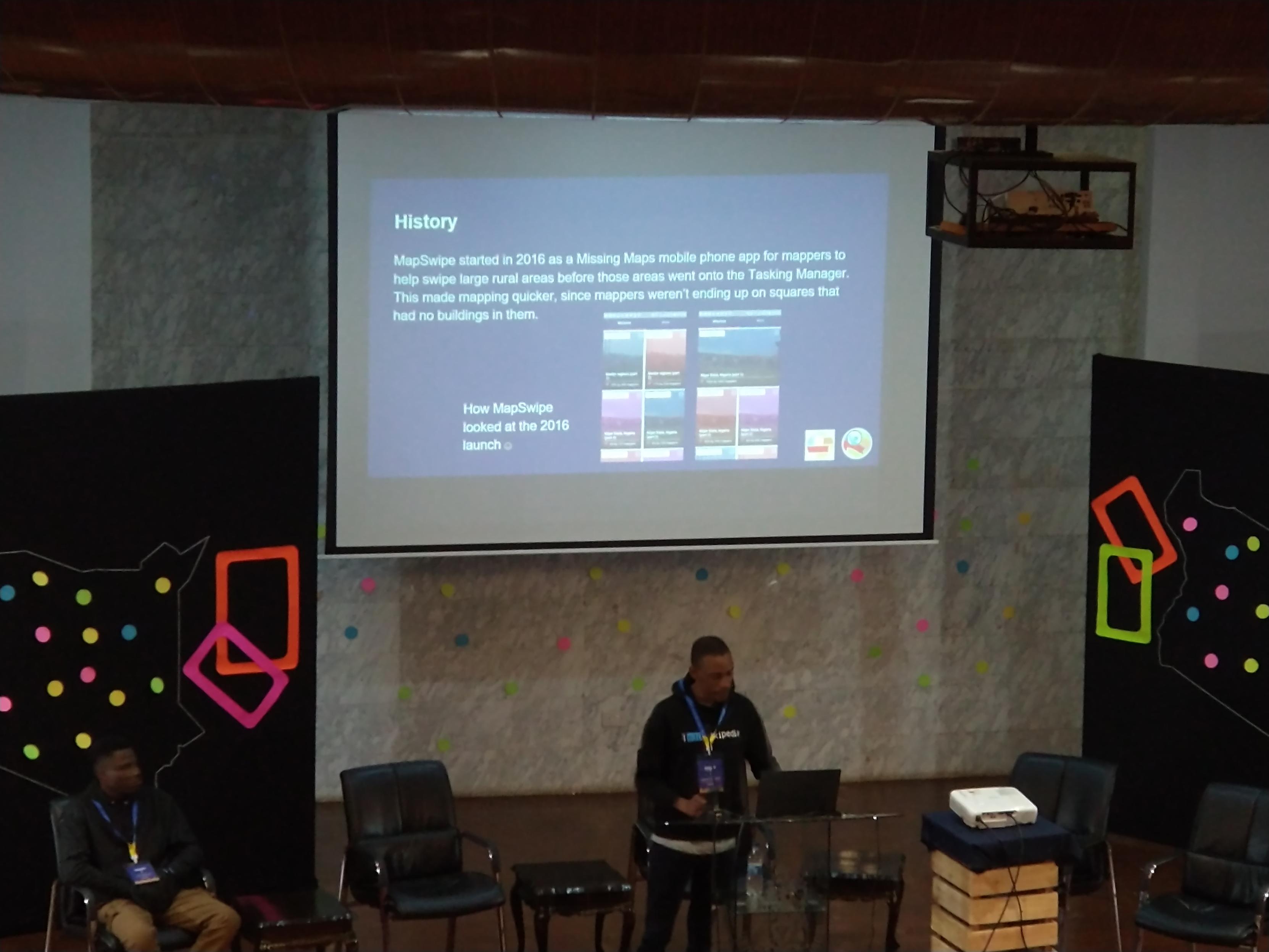
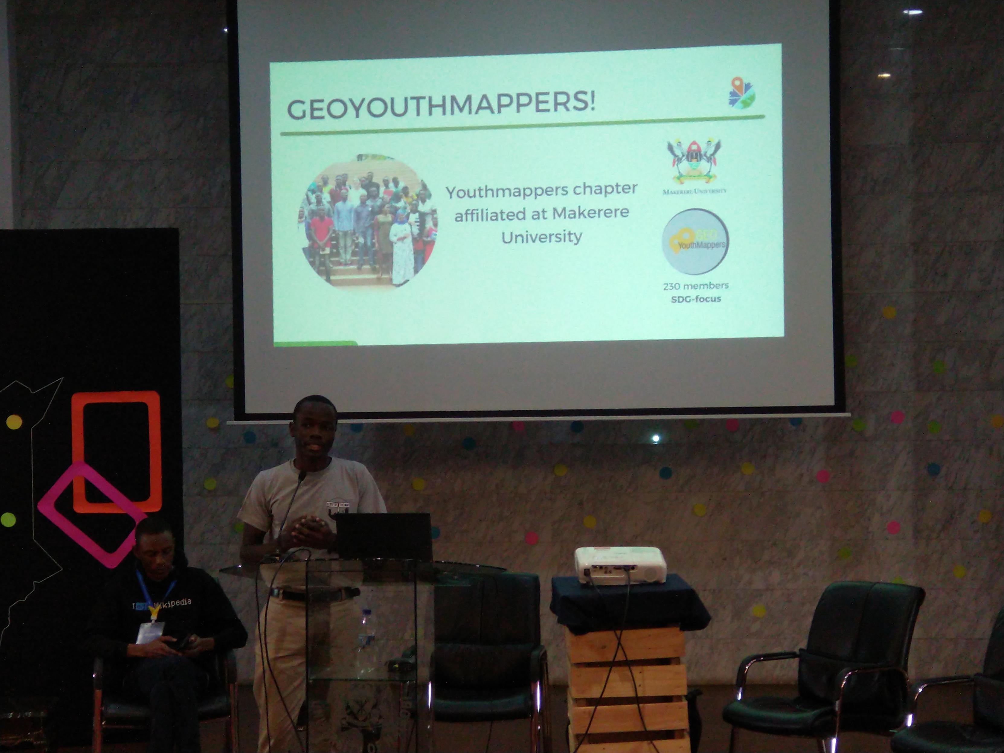
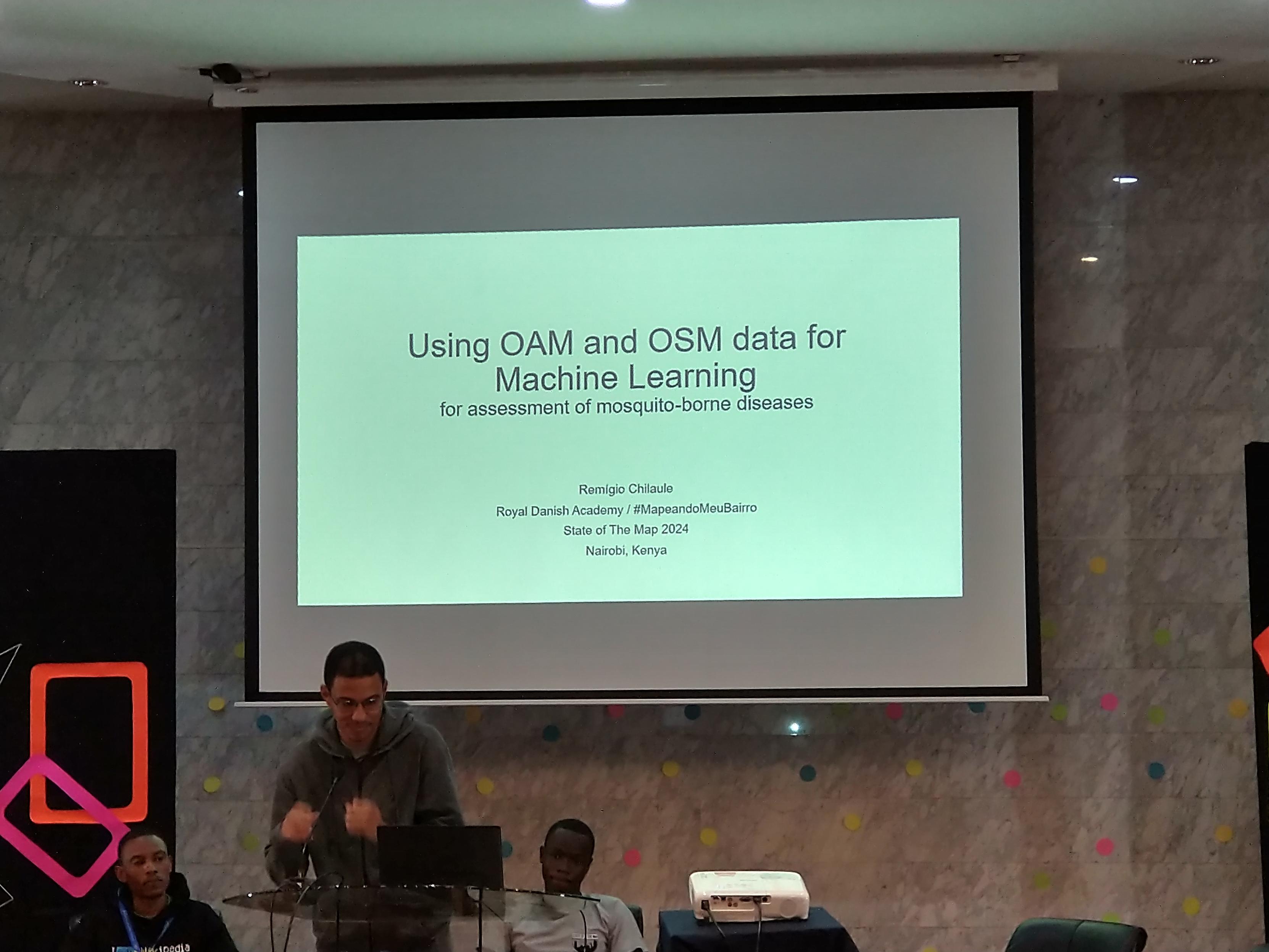
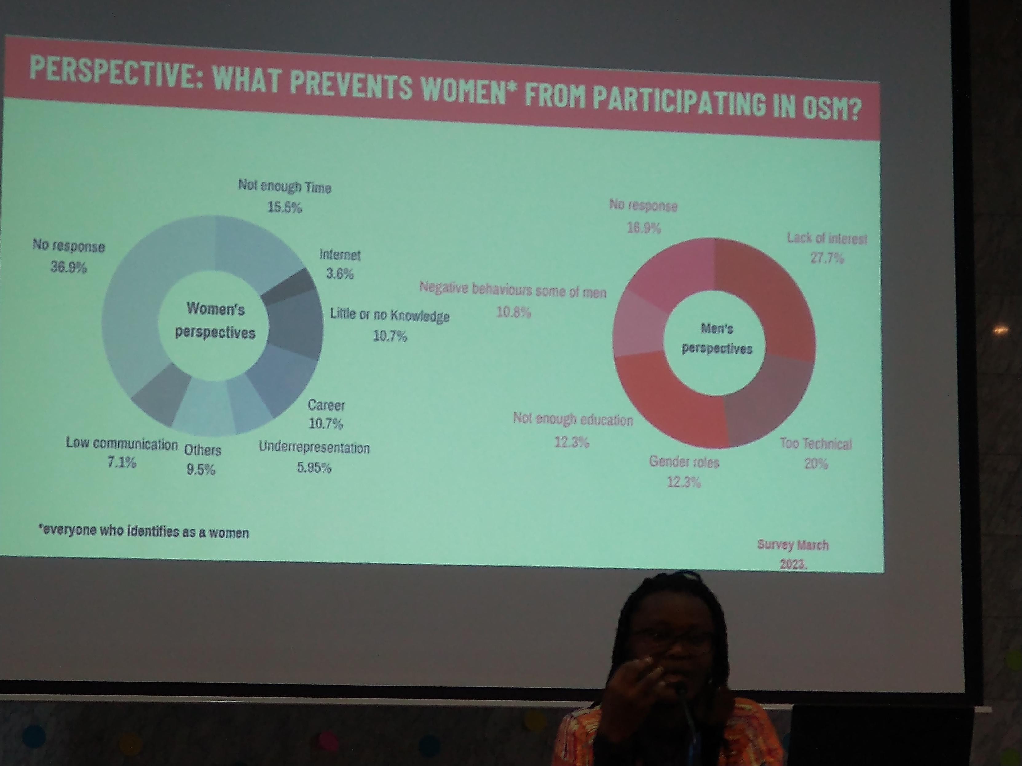
#sotm2024 #lightningtalks III showcasing #mapswipe for web launch, @youthmappers chapter in Makerere University #uganda, #machinelearning project involving #dronemapping in #mozambique and #surveyresults regarding what prevents women participating more in #openstreetmap comparing men and women answers (that differ!)
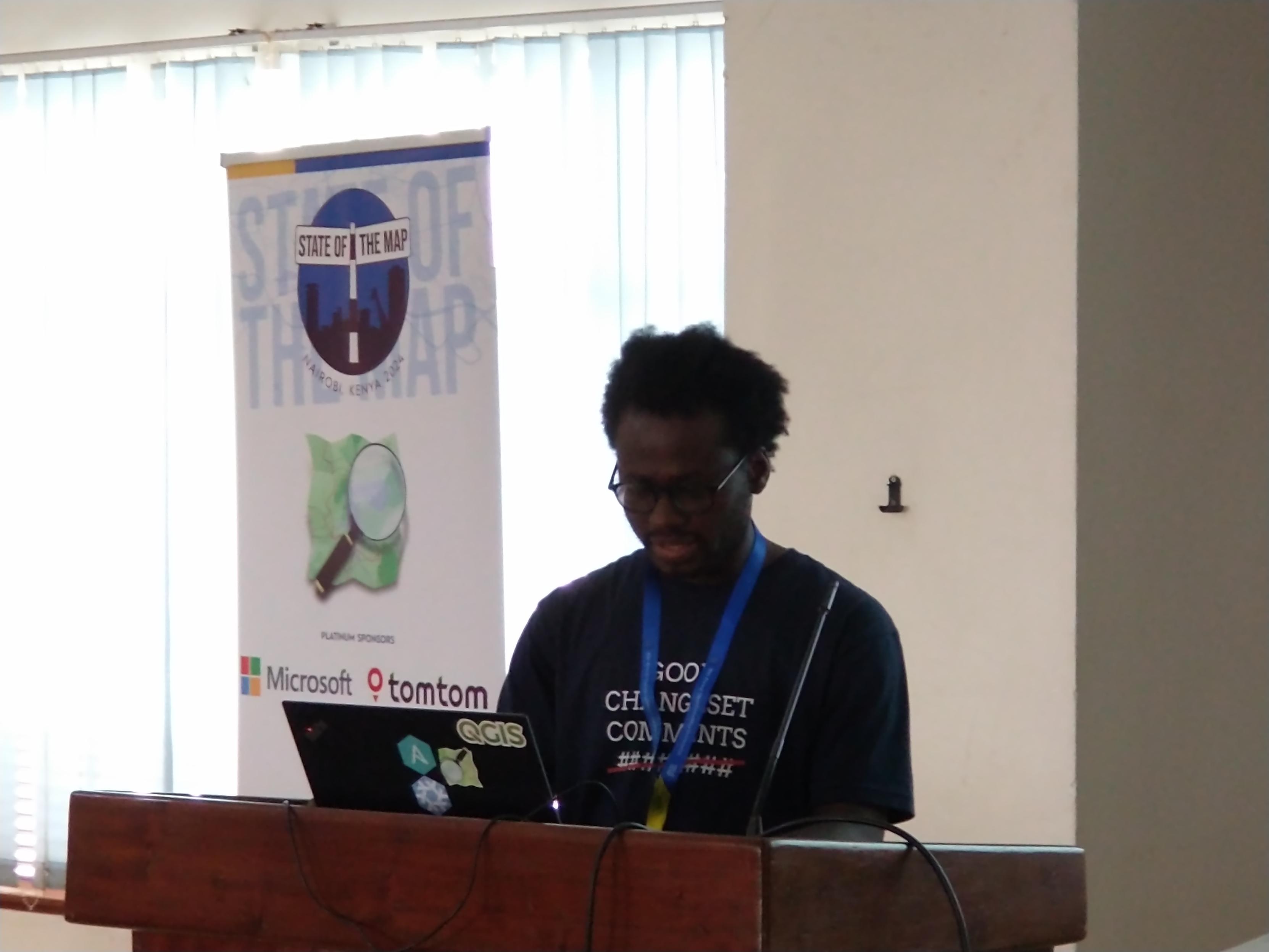
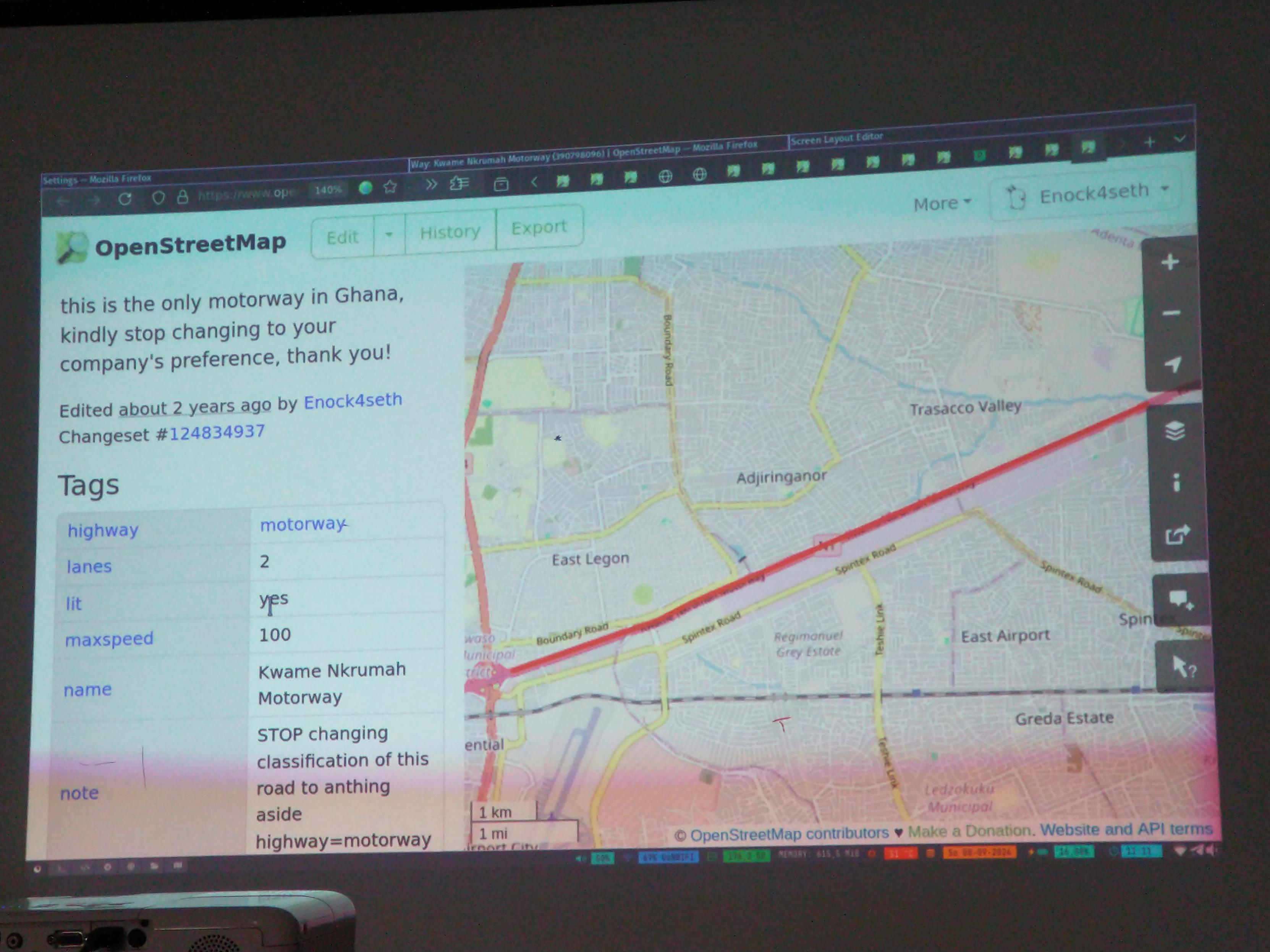
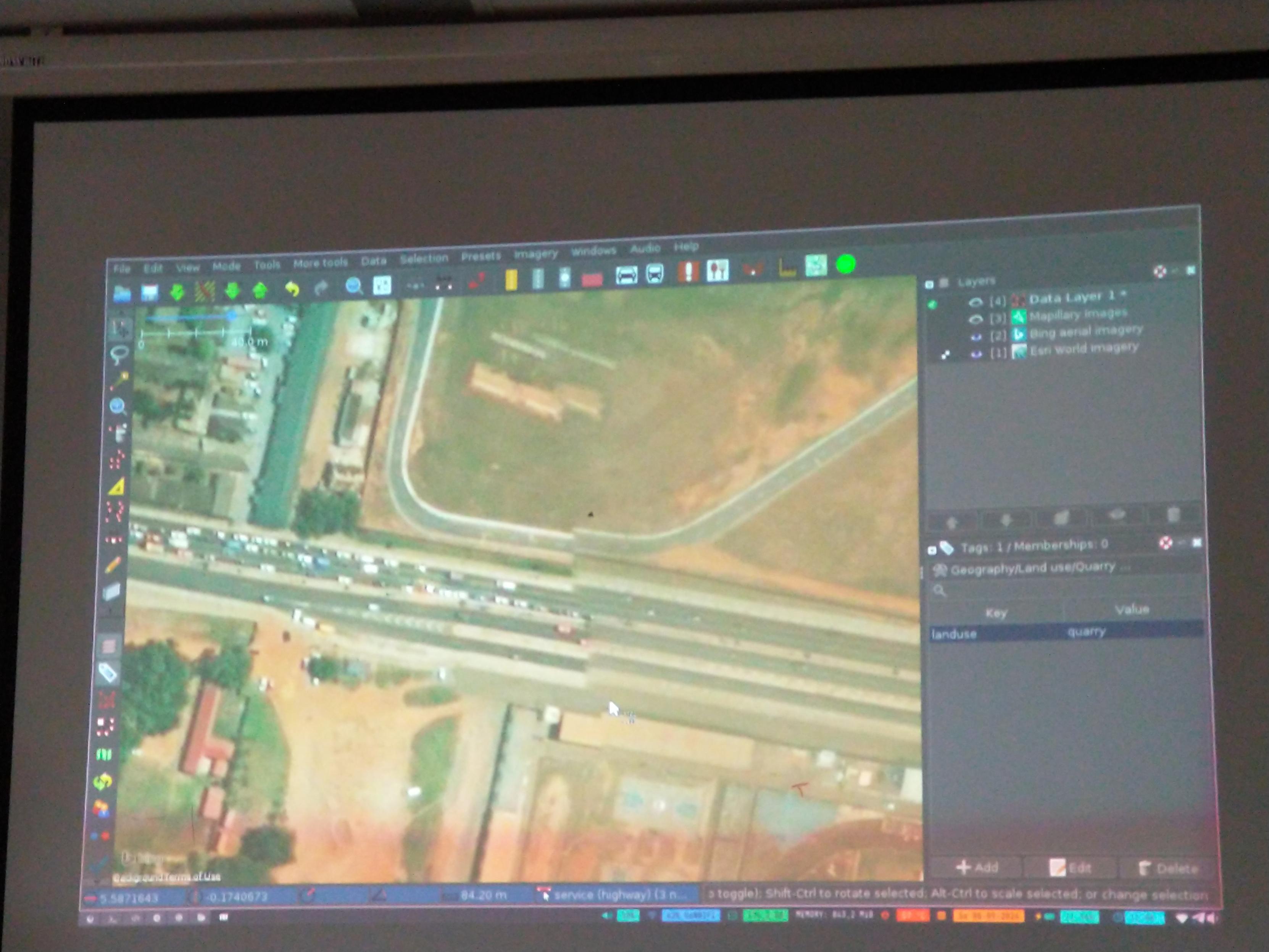
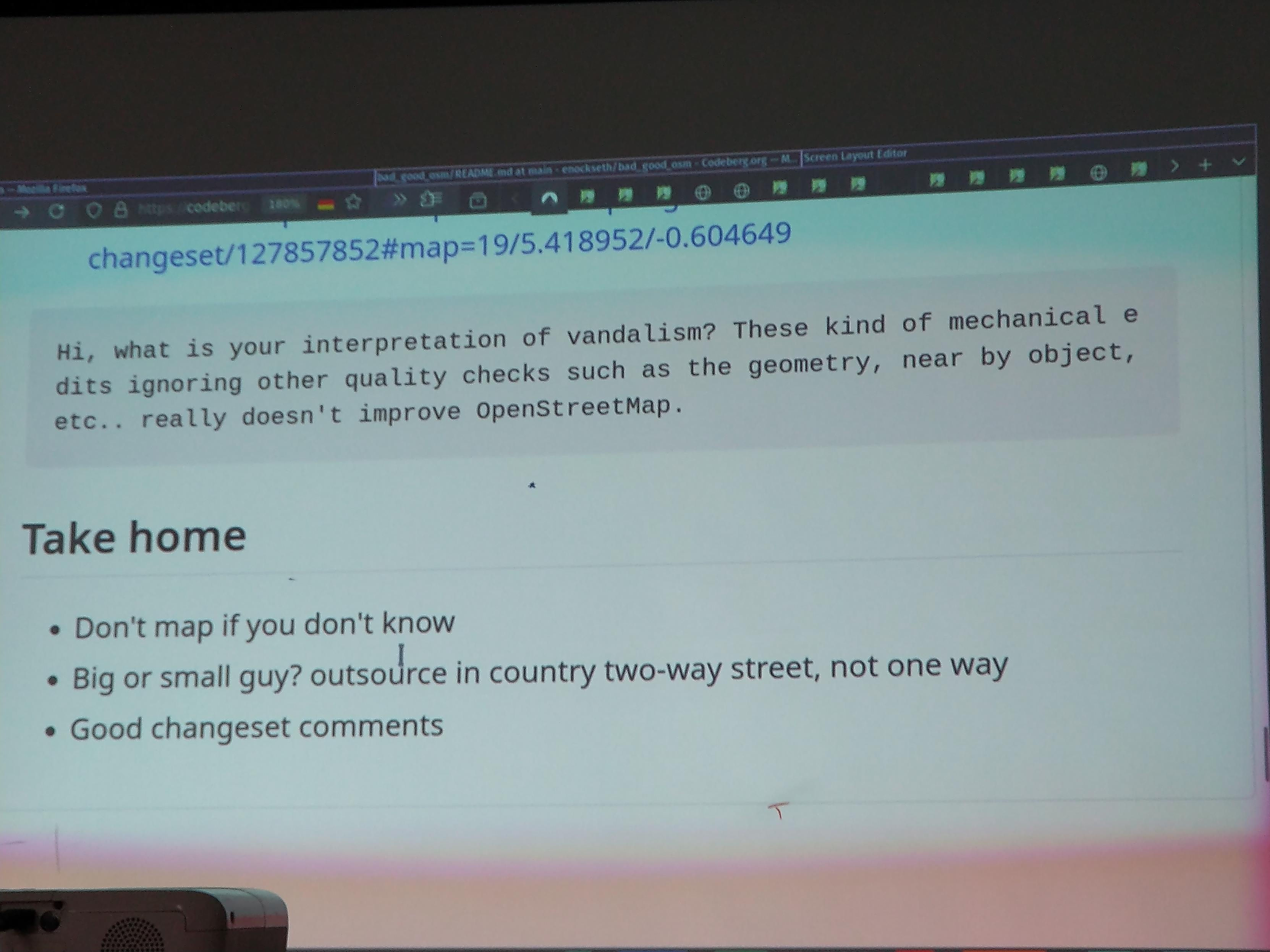
#SotM2024 @Enock4seth showing worst and best of #OpenStreetMap #opendata in #Ghana through various cases of personal or organized #mapping and sharing the fundamental requirements and recommendations to avoid damaging the #dataquality
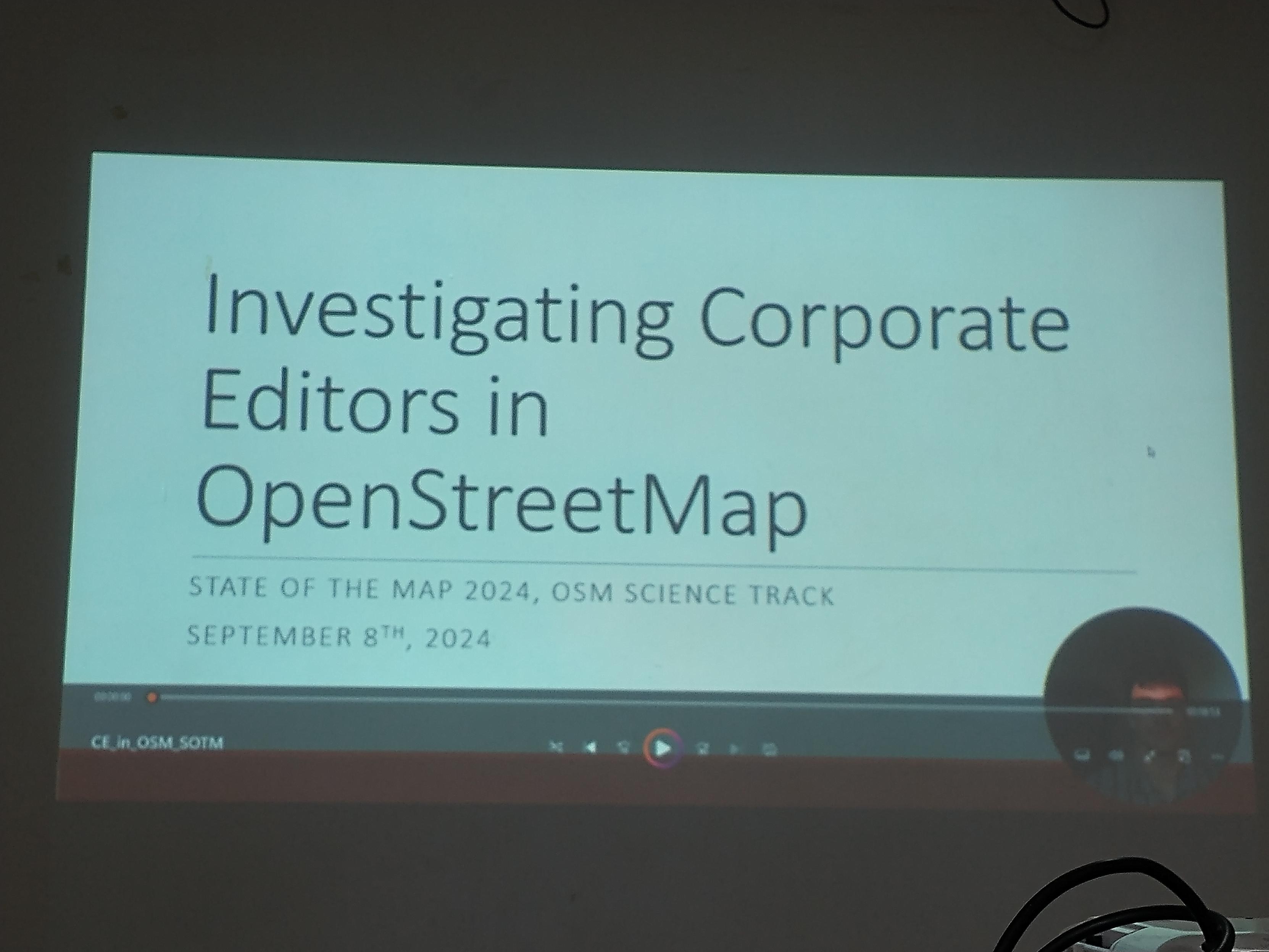
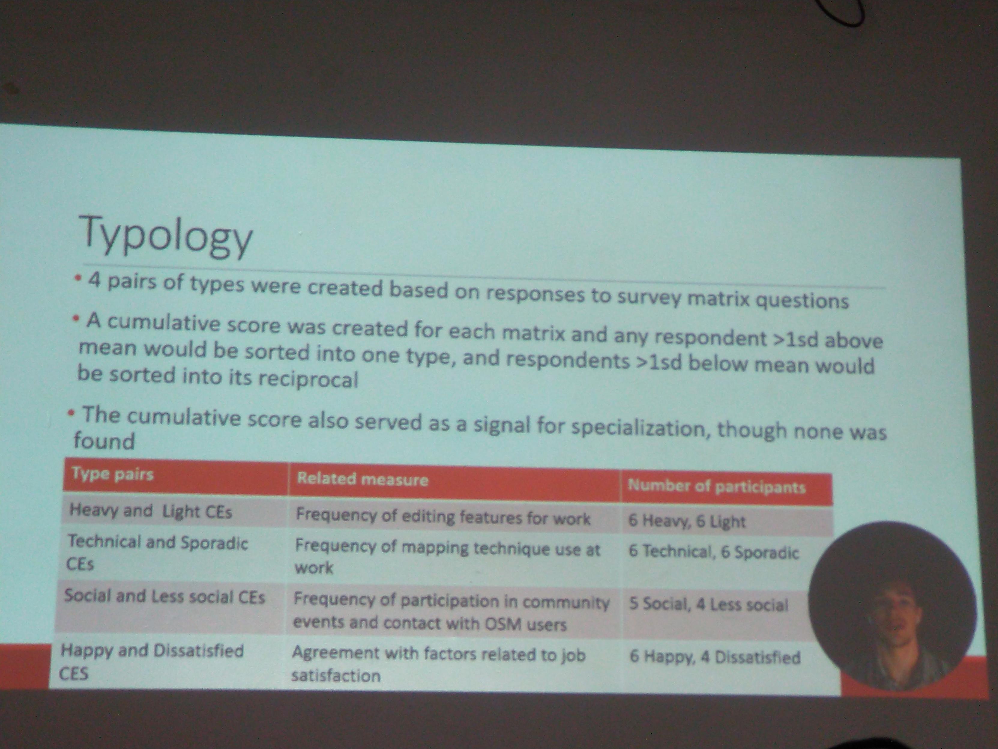
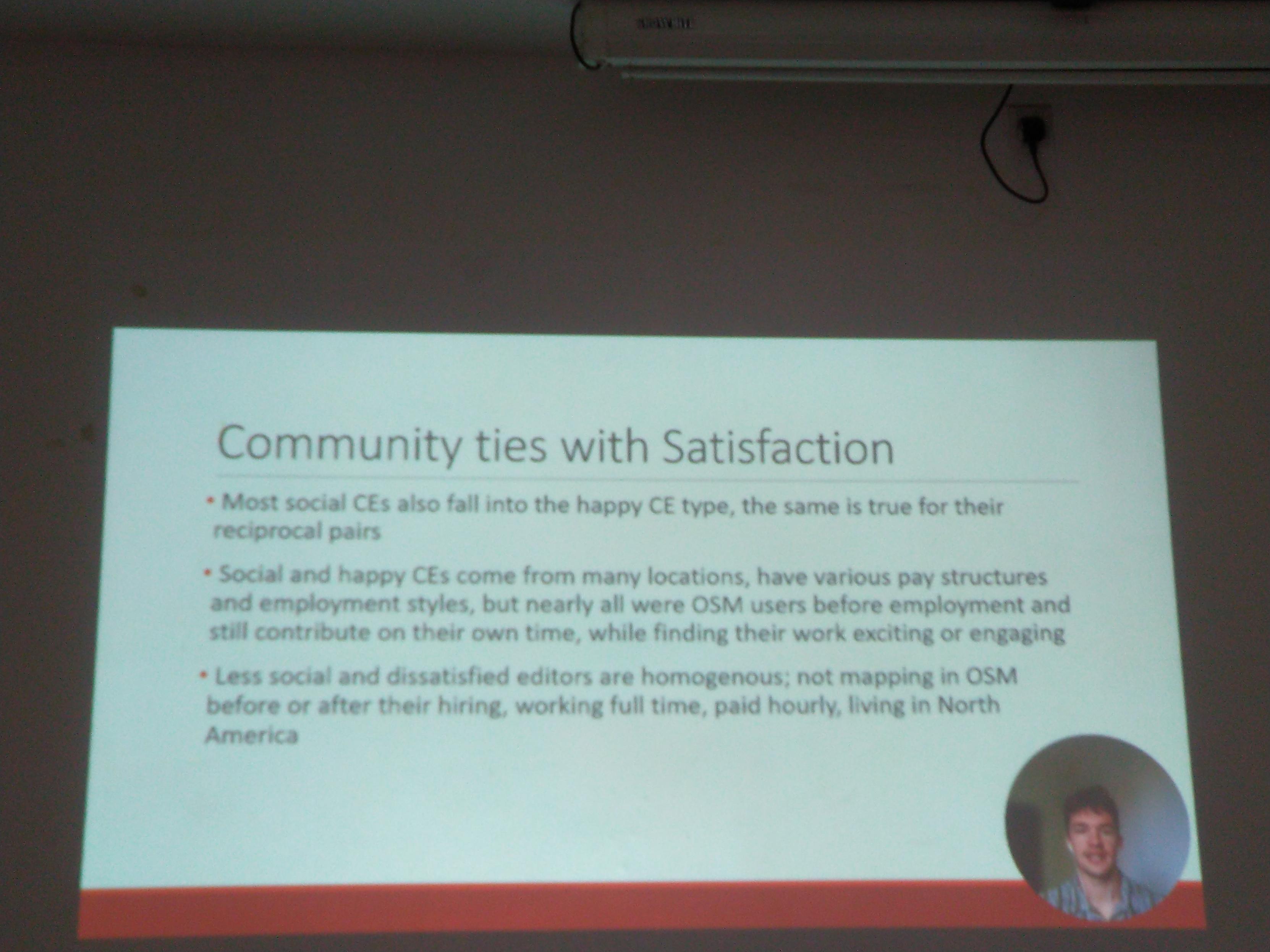
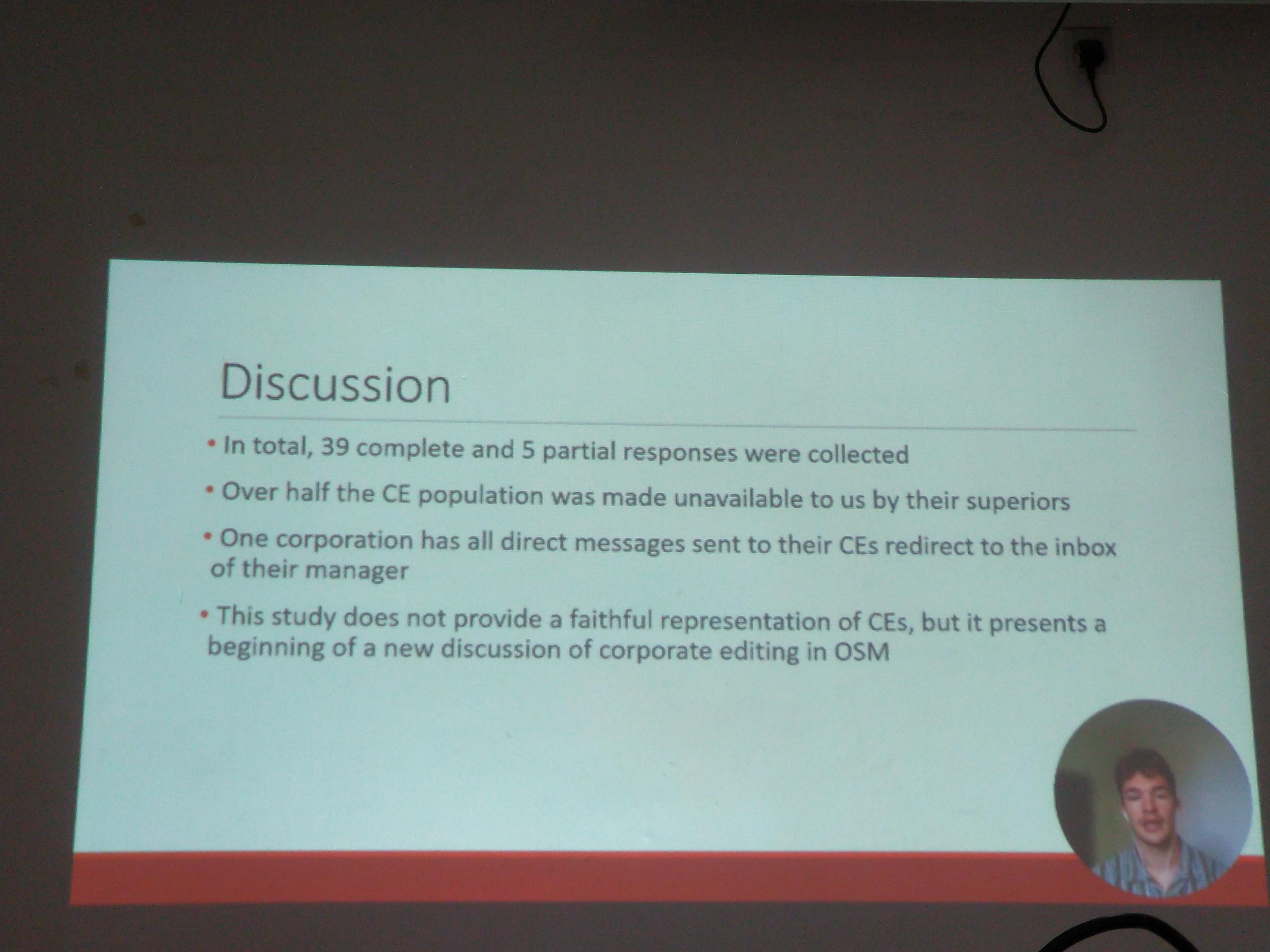
#sotm2024 Alex Hoferek presents #surveyresults about #openstreetmap #corporate editors with a #typology mixing numbers of editing, variety of used techniques, #community involvement and #jobsatisfaction. Part of answers unfortunately controlled or blocked by managers. But in short, the more these CEs engage with the community, the more they are happy!
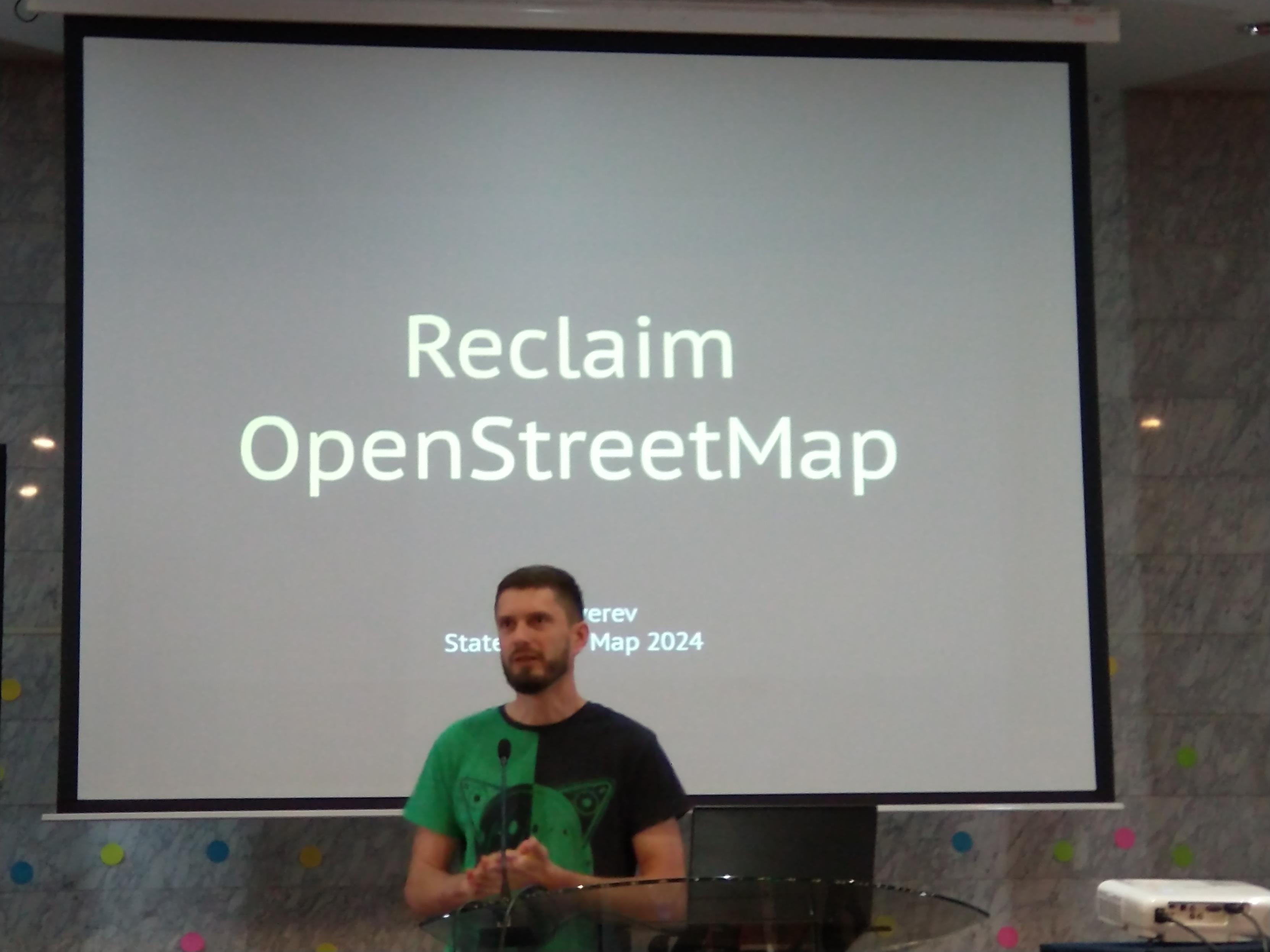
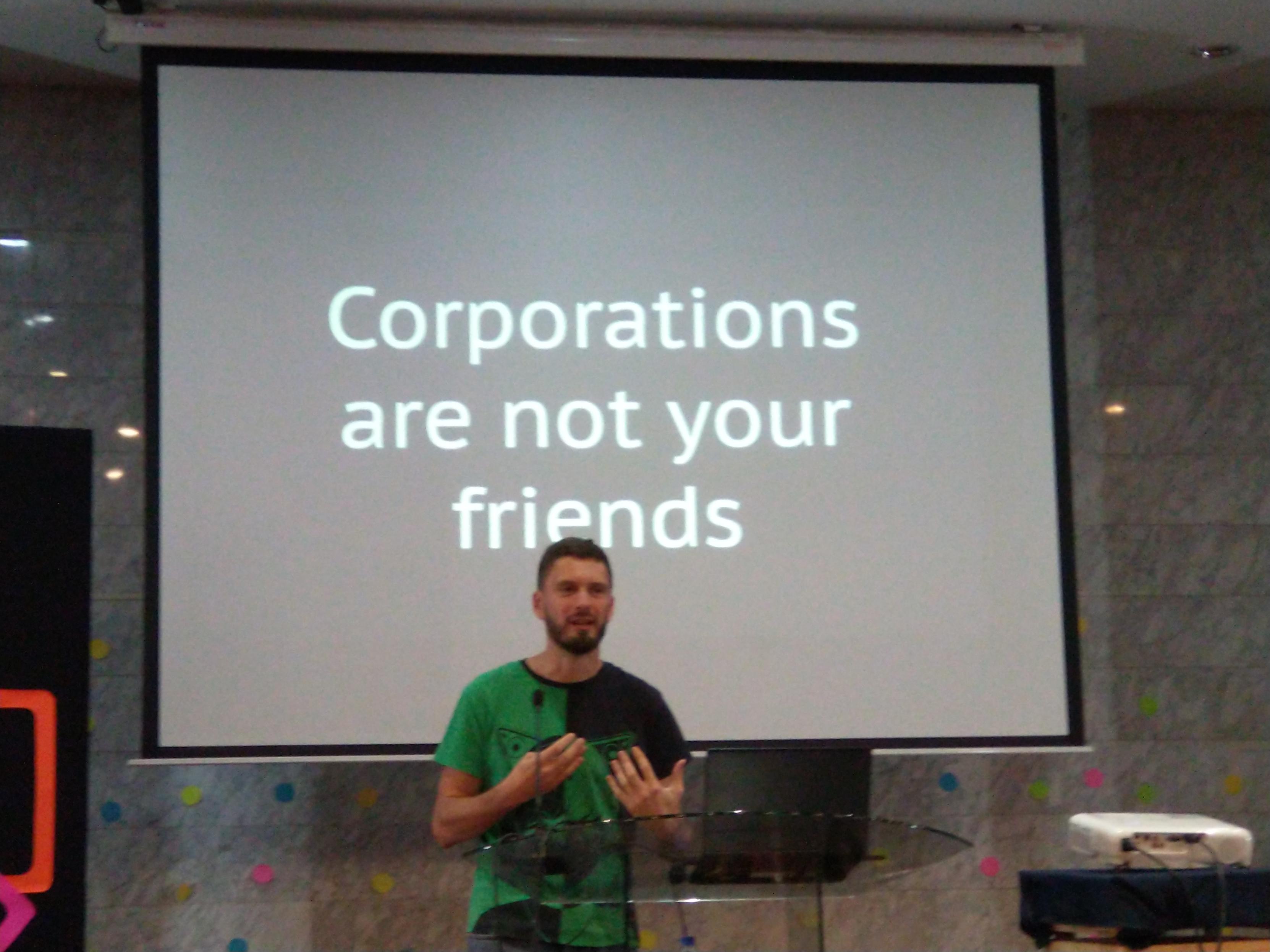
#sotm2024 @zverik retraces the history of #osm #fieldmapping, encourages reclaiming #openstreetmap from corporations and improving the newcomers first experience when joining osm.org
Thank you for great SotM global conference!
See you next time, OSM mappers!
#sotm #sotm2024 #OpenStreetMap #Nairobi #FuruhashiLab #古橋研究室 #AoyamaGSC #Polimi


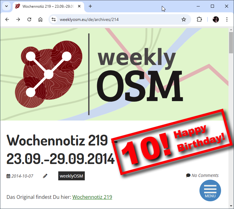
OpenStreetMap: 10 Jahre Wochennotiz! https://geoobserver.de/2024/10/14/openstreetmap-10-jahre-wochennotiz/ #osm #openstreetmap #weeklyOSM #gistribe #gischat #fossgis #foss4g #OSGeo #spatial #geospatial #opensource #geoObserver pls RT
@openstreetmap @osm_tech @Firefishy I think we have to give credit where credit is due: #Openstreetmap and #GIS stuff in #Debian is as good as it is today because Sebastiaan Couwenberg does an amazing job as Maintainer of the Debian GIS Project.
OpenStreetMap migrates to Debian 12: You may have seen this toot
announcing OpenStreetMap's migration to Debian on their infrastructure.
🚀 After 18 years on Ubuntu, we've upgraded the
@openstreetmap servers to Debian 12
(Bookworm). 🌍 openstreetmap.org is now faster
using Ruby 3.1. Onward to new mapping adventures! Thank you to the team for
the smooth transition.
#OpenStreetMap
#Debian 🤓
We spoke with Grant Slater, the Senior Site Reliability Engineer for the… https://bits.debian.org/2024/11/openstreetmap-on-debian.html
13 years ago I mapped hiking paths near by relative's village. Every path because #openstreetmap was empty in the area except main (car) roads. Today I noticed the village has a new information board of suggested hiking routes. The map: "copyright OpenStreetMap contributors". Made me a bit proud.
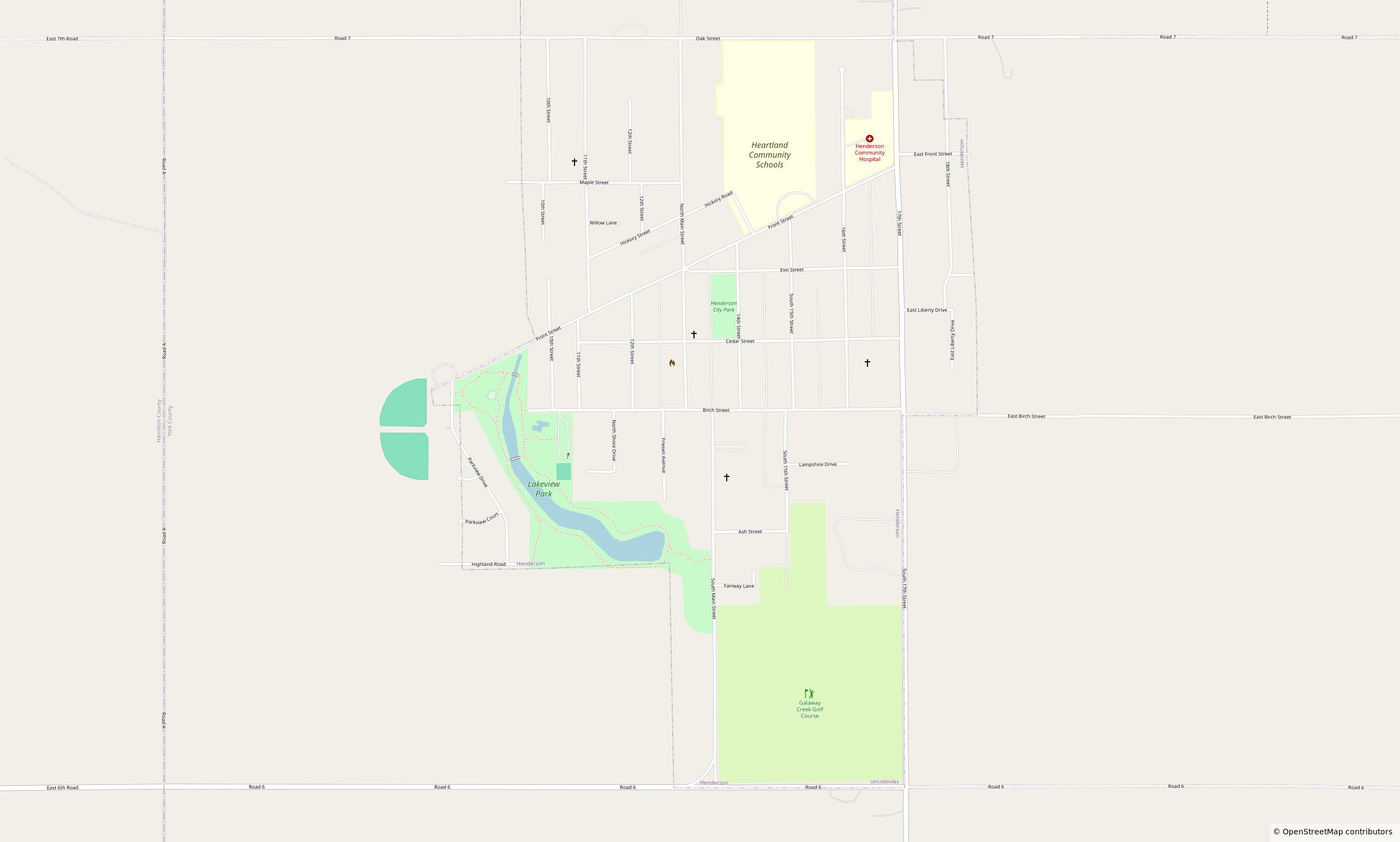
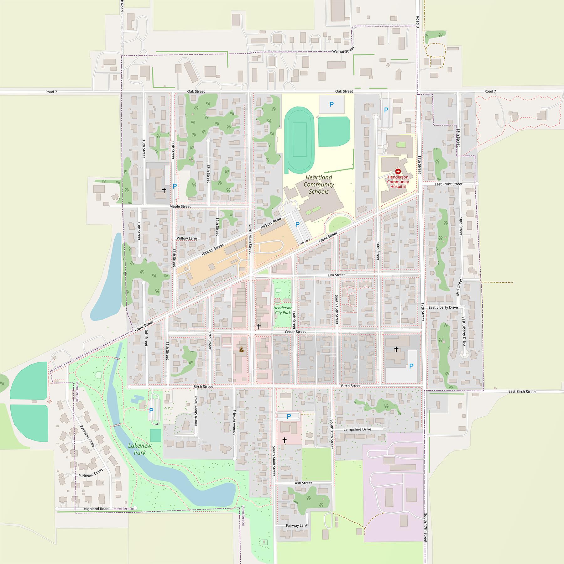
Went back to Henderson to finalize the updates. I think i updated all i could with out starting to assume details. Also some mappers suggested straightening out the roads, so i did that across the entire town.
https://www.openstreetmap.org/#map=16/40.78138/-97.81154&layers=N
Included are the original before photo, and the final after.
As a side note, bing was working on JOSM for a minute and then stopped again.
I love #OpenStreetMap and I love #Mozilla but I do not understand what the strategy is here:
https://blog.mozilla.ai/map-features-in-openstreetmap-with-computer-vision/
It reads like looking for problems to apply AI to for "thought leadership" — and some ten years late at that.
OpenStreetMap has many players using machine learning; from big players to open source pipelines and models. It's not a technical problem to solve.
What are you doing Mozilla? Have you talked to anyone in the OpenStreetMap community?

Downloading the maps in #OpenStreetMap is really slow in #Malaysia . I have to retry dozens of times to download a 170MB map. I wish they had a system of mirrors or CDNs.
Edit: Oops, it's the Organic Maps app, where the downloading of maps is slow. Is there any way to download maps faster, @organicmaps ?
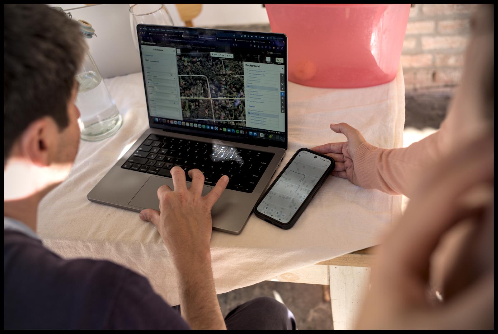
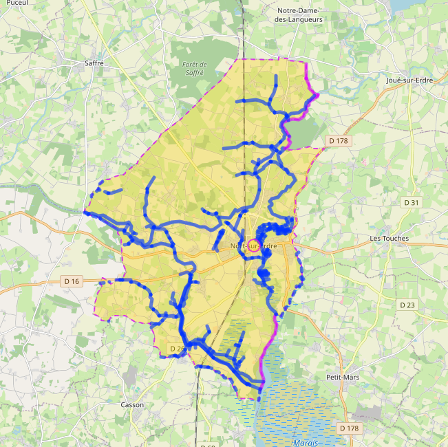
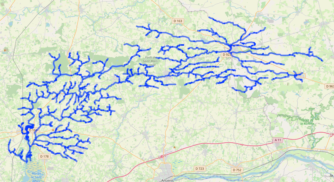
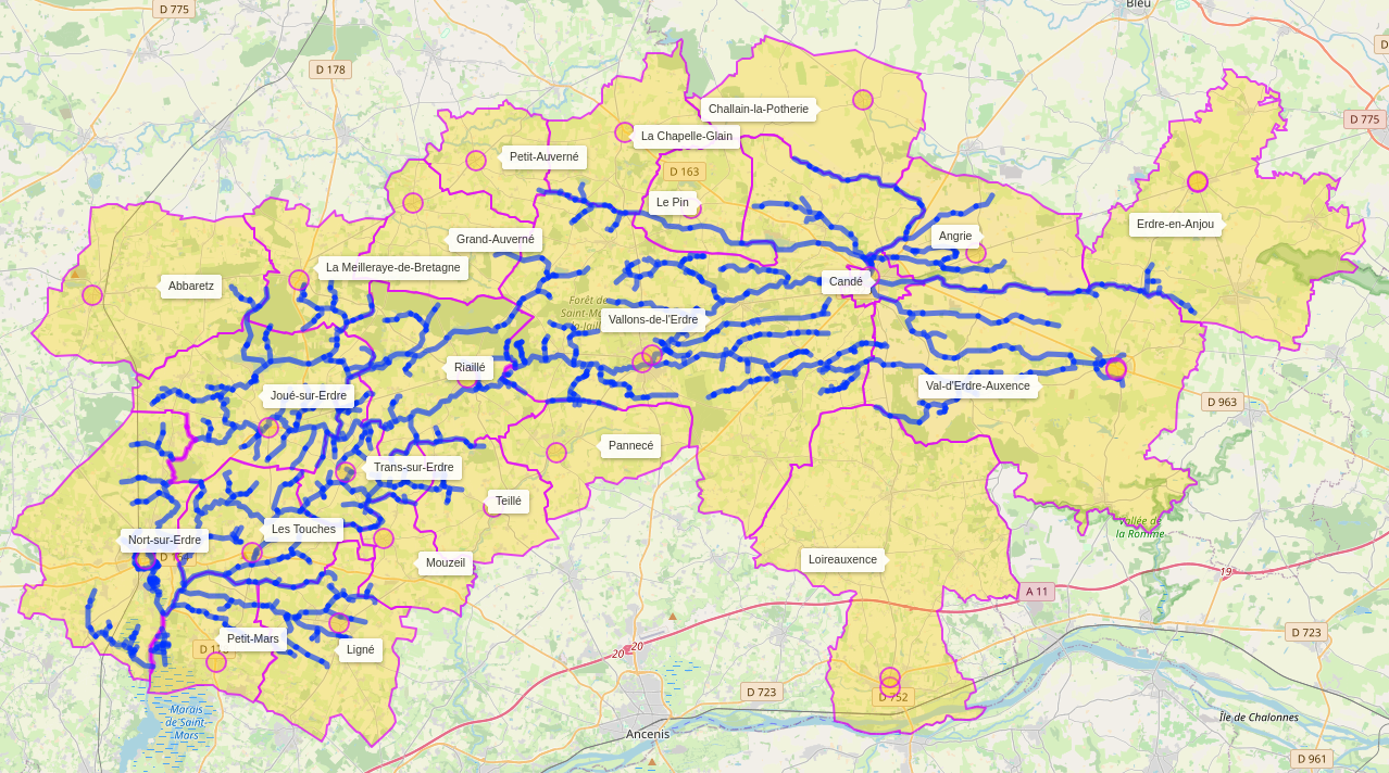
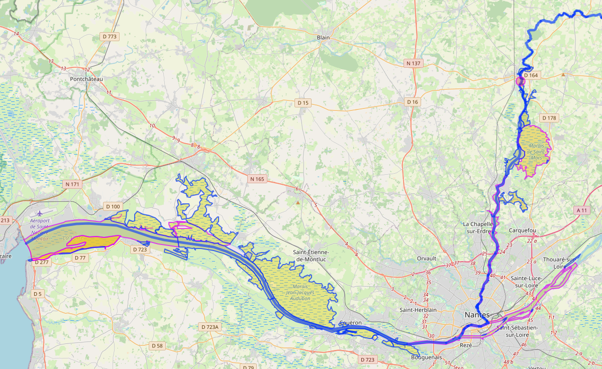
Pour la Journée Mondiale de l'Eau #worldwaterday ce samedi 22 mars, je vous ai concocté quelques requêtes Overpass sympathiques qui valorisent les données hydrographiques présentes dans #OpenStreetMap.
Légende des visuels :
➡️ Rivières d'une commune
➡️ Cours d'eau en amont d'un point
➡️ Communes d'un bassin versant
➡️ De la source à l'Océan, avec les plans d'eau traversés et les zones humides adjacentes
Les requêtes et quelques explications sont dans cet article : https://www.osm.org/user/Carto'Cit%C3%A9/diary/406400
Just rolled the stable releases for GNOME 48
GNOME Maps 48: https://download.gnome.org/sources/gnome-maps/48/
libshumate 1.4.0: https://download.gnome.org/sources/libshumate/1.4/
And also 47.5 for Maps with a cherry-pick for the update to use Transitous for public transit routing in Finland (due to Digitransit sunsetting the old OpenTripPlanner 1.x API in April).
And now rest and fika for the rest of the day 😀
#gnome #gnomemaps #libshumate #gnome48 #mapstodon #openstreetmap #transitous #fika
TIL about @beacondb
This is one of those projects that reminds me of the early days of #openstreetmap, when the dataset was sparse and parts of the road network weren't fully mapped.
Contributing is really easy. Just run one of the apps listed on the homepage and take a walk around your neighbourhood.
Went back to Henderson to finalize the updates. I think i updated all i could with out starting to assume details. Also some mappers suggested straightening out the roads, so i did that across the entire town.
https://www.openstreetmap.org/#map=16/40.78138/-97.81154&layers=N
Included are the original before photo, and the final after.
As a side note, bing was working on JOSM for a minute and then stopped again.
Celebrating 5000 changesets on #OpenStreetMap
#Introduction (l'était temps !😀)
Ici depuis 2020, vous trouverez là beaucoup de repouets et de contenu autour d'OpenStreetMap🌍, Panoramax📷 (GoPro Max) et la cartographie🗺️ en général.
Je suis aussi utilisateur heureux de l'anneau contraceptif ⭕Andro-switch et promeut son usage et sa certification (➡️ coopérative Entrelac).
J'aime tout l'internet qui bidouille et j'ai une passion honteuse pour les YouTube Poop🤪 .
#OpenStreetMap #Panoramax #Androswitch #Entrelac #MontyPython #YouTubePoop #PireTube
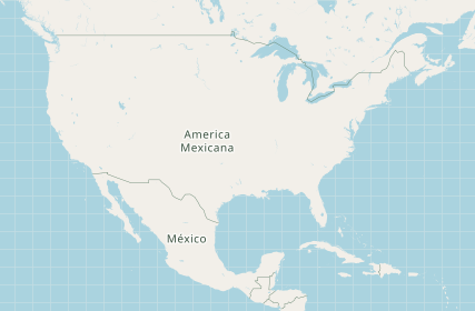
My map of the day as suggested by the president of #Mexico
Runnning an #Openstreetmap Tileserver? Just call the following SQL:
update planet_osm_polygon set name='America Mexicana' where osm_id=-148838;
Have you ever collected data for #OpenCellID #MozillaLocationService #WiGLE or #BeaconDB ?
Please retoot!
@[email protected] @[email protected]
@WiGLEnet
@BrodieOnLinux
#opensource #opendata #openstreetmap #foss #networklocation #mls #microg #grapheneos #geoclue #towercollector #neostumbler
13 years ago I mapped hiking paths near by relative's village. Every path because #openstreetmap was empty in the area except main (car) roads. Today I noticed the village has a new information board of suggested hiking routes. The map: "copyright OpenStreetMap contributors". Made me a bit proud.
It's time for the traditional yearly wrap-up blog post!
https://ml4711.blogspot.com/2024/12/christmas-winter-end-of-year-holidays.html
🎄🎅🗺️

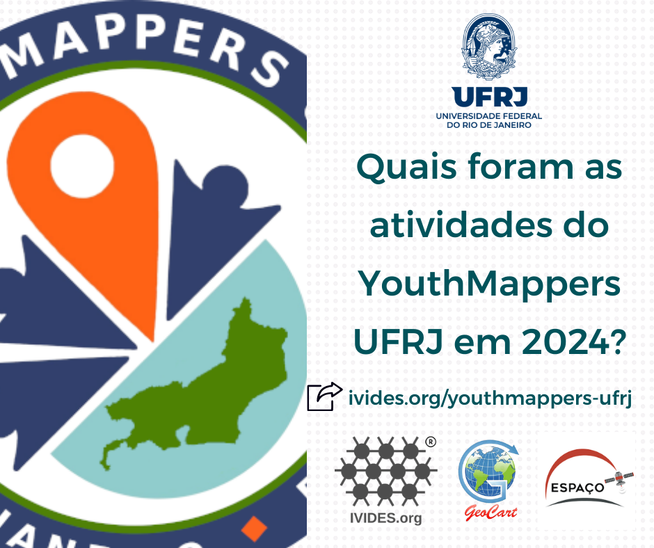
2024 YOUTHMAPPERS UFRJ PRODUCTION
Our YouthMappers chapter celebrated its first anniversary in May 2024 and we're still going strong, with open training activities and mapping projects with the lovelly #OpenStreetMap.
This year, we incorporated uMap (FR) into the basic OSM course in order to offer more resources to those who follow us. Only in 2024, there were 17 training sessions (Short courses) and 700 certificates were issued.
https://ivides.org/youthmappers-ufrj
🇧🇷🌎


I wonder why @openstreetmap 'Find directions between two points' function do not have the option for public transport routes?
Moreover, when at least Valhalla seems to include them (https://www.mapzen.com/products/mobility/turn-by-turn/, through transitland) (, and maybe GraphHopper [https://www.graphhopper.com] too?)
I found this question here too:
https://www.reddit.com/r/openstreetmap/comments/v914h0/website_for_public_transit_routing/
And not only OsmAnd @organicmaps and Transportr (through https://navitia.io/) include this function, but the other resources seem very powerful, particulartly transitland (https://www.transit.land), travic/Movility Portal by geOps (https://mobility.portal.geops.io), mapset (https://mapset.io/en), and the Public Transport Enabler (https://github.com/schildbach/public-transport-enabler, https://gitlab.com/oeffi/public-transport-enabler) and Oeffi (https://gitlab.com/oeffi/oeffi)
#OpenStreetMap #PublicTransport #transitland #geOps #mapset #PublicTransportEnabler
Athens is super well mapped on OpenStreetMap, the acropolis too!
In the past 4 days I have been moving around by using @organicmaps only 💕
#OpenStreetMap #OSM #Fairphone #Athens #acropolis #Greece #maps #OrganicMaps
@openstreetmap @osm_tech @Firefishy I think we have to give credit where credit is due: #Openstreetmap and #GIS stuff in #Debian is as good as it is today because Sebastiaan Couwenberg does an amazing job as Maintainer of the Debian GIS Project.
OpenStreetMap migrates to Debian 12: You may have seen this toot
announcing OpenStreetMap's migration to Debian on their infrastructure.
🚀 After 18 years on Ubuntu, we've upgraded the
@openstreetmap servers to Debian 12
(Bookworm). 🌍 openstreetmap.org is now faster
using Ruby 3.1. Onward to new mapping adventures! Thank you to the team for
the smooth transition.
#OpenStreetMap
#Debian 🤓
We spoke with Grant Slater, the Senior Site Reliability Engineer for the… https://bits.debian.org/2024/11/openstreetmap-on-debian.html
OpenStreetMap: 10 Jahre Wochennotiz! https://geoobserver.de/2024/10/14/openstreetmap-10-jahre-wochennotiz/ #osm #openstreetmap #weeklyOSM #gistribe #gischat #fossgis #foss4g #OSGeo #spatial #geospatial #opensource #geoObserver pls RT
Congratulations, weeklyOSM!
The editorial board of the #weeklyOSM is celebrating the ten years of this weekly that share the news about the #OpenStreetMap World, every week, since 2014! Congratulations for all who contribute to this initiative!


Over the past few months, I played around with OpenStreetMap a lot so as to learn some Blender basics. As there was a lack of a comprehensive guide out there on the Internet, I published something for the first time in ages.
"Importing OpenStreetMap data into Blender using JOSM and OSM2World"
Thank you for great SotM global conference!
See you next time, OSM mappers!
#sotm #sotm2024 #OpenStreetMap #Nairobi #FuruhashiLab #古橋研究室 #AoyamaGSC #Polimi
#sotm2024 @zverik retraces the history of #osm #fieldmapping, encourages reclaiming #openstreetmap from corporations and improving the newcomers first experience when joining osm.org
#sotm2024 Alex Hoferek presents #surveyresults about #openstreetmap #corporate editors with a #typology mixing numbers of editing, variety of used techniques, #community involvement and #jobsatisfaction. Part of answers unfortunately controlled or blocked by managers. But in short, the more these CEs engage with the community, the more they are happy!
#SotM2024 @Enock4seth showing worst and best of #OpenStreetMap #opendata in #Ghana through various cases of personal or organized #mapping and sharing the fundamental requirements and recommendations to avoid damaging the #dataquality
#sotm2024 #lightningtalks III showcasing #mapswipe for web launch, @youthmappers chapter in Makerere University #uganda, #machinelearning project involving #dronemapping in #mozambique and #surveyresults regarding what prevents women participating more in #openstreetmap comparing men and women answers (that differ!)
#Sotm2024 #openstreetmap social event at Bao Box
#sotm2024 Stefan Keller presenting ongoing research on #opendata #conflation in #openstreetmap introducing #diffedplaces created by Claudio Bertozzi and an improved forked version of #osmconflator
#sotm2024 Mateusz Konieczny presenting all what the #osmfoundation does to support without controlling the #openstreetmap #opendata and its vibrant #community
#sotm2024 thanks to the local technical team broadcasting the event from #nairobi to the remote #openstreetmap #community!
Members from diverse countries gather around the table to discuss cutting-edge geospatial technology.
#sotm #sotm2024 #OpenStreetMap #Nairobi #FuruhashiLab #古橋研究室
#sotm2024 yesterday Michael Montani introduced to #validation tools to improve #openstreetmap #opendata and #mappers skills based on the specific #unmaps #mooc course about it https://mappers.un.org/learning
#sotm2024 yesterday Anastazia Caroll told her journey as a #womanintech, how she went beyond her fears of not being technical enough to embrace #geomatics and #openstreetmap and how she enjoyed to improve her skills and being able to deliver strong products now
#sotm2024 yesterday Yvonne Darko told how she organized a street views collection in her village to map pharmacies and addresses in #openstreetmap. I like she used #wikicommons to host the pictures
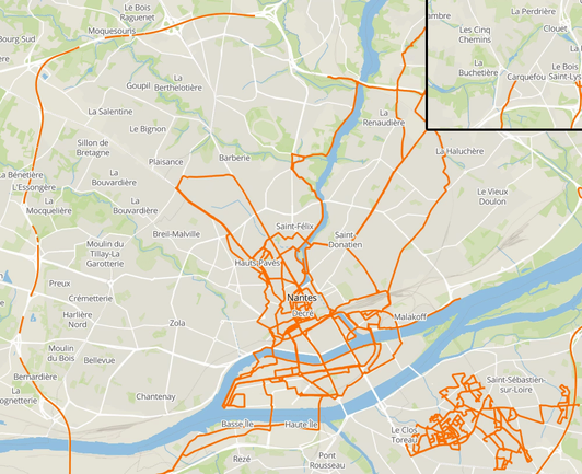
🛣️ 611 km de rues cumulées
📸 97900 photos prises sur 57 heures (dont 35h à vélo et 22h à pied)
🎬 78 séquences
🕝 20 jours de capture étalés sur 5 semaines
🌳 5 coulées vertes et bord de rivière capturés
🎓 1 campus universitaire et 🏰 1 château capturé
La commune de Nantes (et un peu Carquefou) a désormais bien plus de rues en 360° qu'avant, même s'il reste beaucoup de travail !
Merci à @naomap (de @cartocite) pour le prêt du kit mobile !
Introducing another #OpenStreetMap based alternative to #HappyCow in order to find #vegan (and #vegetarian) restaurants on mobile devices via #OSMand.
Available via #fDroid and the stores listed on their homepage: https://osmand.net/
The screenshots show German dialogues, but I provide an English description in the alt texts.
1/2
Are you aware of #VeggieKarte? 🌱 🗺️
It is an #OpenStreetMap based service to find #vegan (and #vegetarian) restaurants, in other words an open alternative to #HappyCow (except for the review functionality).
You can contribute by maintaining entries via your #OSM account and the source code is deposited on #codeberg.
préparation de l'envoi de moultes photos 360 pour #panoramax prises en trottinette élec pendant le weekend du #FOSDEM 2024 à #Bruxelles
Previously I compared #AppleMaps to #OpenStreetMap in Latvia.
https://mastodon.social/@richlv/111402843227612917
Ended up on #GoogleMaps from a website, and it didn't seem to depict reality. Had to compare it with OSM.
Missing major buildings, roads. Incorrect roads (NE one is a mostly a path). And that's ignoring all the detail, available in OSM.
Oh, and that "bar" on the left in Google Maps? That's a spam entry, advertising bar services for events.
Ce style cartographique (basé sur les données #OpenStreetMap) qui se concentre sur le paysage urbain est magnifique 🤩
🖥 Le code source : https://github.com/SupaplexOSM/strassenraumkarte-neukoelln/tree/main/mapstyle
🗺 Un superbe exemple en ligne : https://strassenraumkarte.osm-berlin.org/?map=micromap#19/52.47391/13.43976
Thanks @Supaplex030 🙏
Hei twitterpārnācēji, kā jau katrā lielākā vilnī, var noderēt idejas, ko te var darīt.
a) Te var sekot haštagiem - piemēram, #Ukraine, #OpenStreetMap.
Haštagus te cenšas lietot ar LielajiemPirmajiemBurtiem, lai saturs būtu pieejamāks cilvēkiem ar redzes grūtībām.
Re-#introduction: recurring topics here.
#Wikimedia #Wikidata #Wikipedia #MediaWiki #OpenStreetMap #Wikimania #Wikisource #WikiCite #OpenRefine #wiki #Wiktionary #WikiLovesMonuments #Wikibase #Wikiquote
#i18n #L10n #translatewiki.net #Unicode #CLDR #languages
#Copyright #PublicDomain #PubblicoDominio #Copyleft #CreativeCommons #OpenData #UploadFilters #LicenzaLibera #DatiAperti
#InternetArchive #books #biblioteche #library #Koha #KohaILS #GLAM
#WikiTeam #digipres #ArchiveTeam #XSLT
1/4
Recording of my talk "How to become an #OpenStreetMap pro":
#introduction
I live in Madison (WI). In my day job, I'm a mixed-methods health researcher (pediatrics and prevention research). Passionate about 🚲, walking, 🚌🚆, landuse. Co-founder and president of local bike advocacy group Madison Bikes, and I serve on the City of Madison Transportation Commission. I use #rstats #rspatial at work and for advocacy (and entertainment). Long-time contributor to #openstreetmap I have a data blog at https://haraldkliems.netlify.app/
Hallo Fediversum!
Obwohl ich bereits einen Account auf @[email protected] hatte, bin ich #neuhier. 👋
#Vorstellung: Als #WiMa an einer 🎓Fachhochschule 👨🏫betreue ich Übungen & 👩🔧Praktika, 👨💻entwickle #Software und 👨🔬betreibe angewandte "#Forschung". In meiner Freizeit trage ich zu 🗺️#OpenStreetMap bei und lerne & spreche 💚#Esperanto. Ich interessiere mich für #funktionale_Programmierung & #funktionale_Programmiersprache|n wie #Haskell und für das  Beibringen des #Programmieren|s.
Saluton Fediverso!
Kvankam mi antaŭe havis konton ĉe @[email protected], mi estas 👋#nova_ĉi_tie.
#Sinprezento: Mi laboras kiel 👨🏫 #instruisthelpanto & 👨💻 #programisto/👨🔬"#esploristo" ĉe 🎓fakaltlernejo. Libertempe mi kontribuas al 🗺️ #OpenStreetMap kaj (evidente) mi estas 💚#Esperantisto. Mi interesiĝas interalie pri #funkciaj_programlingvoj kiel #Haskell kaj pri #instruado de #programado.
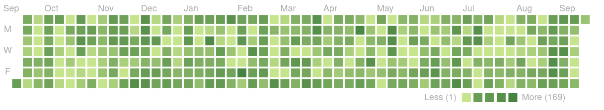
Ein persönlicher Meilenstein: 366 Tage lang jeden Tag zu #OSM beigetragen. Habe ich damit #OpenStreetMap durchgespielt? Ich "fürchte" nicht. 
Danke an #StreetComplete ,#josm, iD uvm.